You are here: Home > Network List > TA - USArray Transportable Network (new EarthScope stations) Stations List
> Station R11A Troy Canyon, Currant, NV, USA > Earthquake Result Viewer
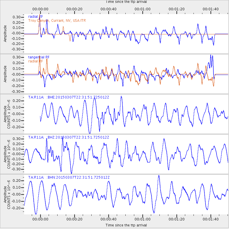
R11A Troy Canyon, Currant, NV, USA - Earthquake Result Viewer
*The percent match for this event was below the threshold and hence no stack was calculated.
| Earthquake location: |
New Britain Region, P.N.G. |
| Earthquake latitude/longitude: |
-6.6/151.7 |
| Earthquake time(UTC): |
2015/03/07 (066) 22:18:58 GMT |
| Earthquake Depth: |
23 km |
| Earthquake Magnitude: |
6.0 MB |
| Earthquake Catalog/Contributor: |
NEIC PDE/NEIC COMCAT |
|
| Network: |
TA USArray Transportable Network (new EarthScope stations) |
| Station: |
R11A Troy Canyon, Currant, NV, USA |
| Lat/Lon: |
38.35 N/115.59 W |
| Elevation: |
1756 m |
|
| Distance: |
96.1 deg |
| Az: |
52.177 deg |
| Baz: |
266.516 deg |
| Ray Param: |
$rayparam |
*The percent match for this event was below the threshold and hence was not used in the summary stack. |
|
| Radial Match: |
50.88248 % |
| Radial Bump: |
400 |
| Transverse Match: |
47.763893 % |
| Transverse Bump: |
400 |
| SOD ConfigId: |
7019011 |
| Insert Time: |
2019-04-17 06:05:31.754 +0000 |
| GWidth: |
2.5 |
| Max Bumps: |
400 |
| Tol: |
0.001 |
|
Signal To Noise
| Channel | StoN | STA | LTA |
| TA:R11A: :BHZ:20150307T22:31:51.725012Z | 1.5534555 | 1.1345548E-7 | 7.3034265E-8 |
| TA:R11A: :BHN:20150307T22:31:51.725012Z | 1.4181646 | 1.5739987E-7 | 1.1098843E-7 |
| TA:R11A: :BHE:20150307T22:31:51.725012Z | 1.8761126 | 1.7109001E-7 | 9.11939E-8 |
| Arrivals |
| Ps | |
| PpPs | |
| PsPs/PpSs | |


