You are here: Home > Network List > N4 - Central and EAstern US Network Stations List
> Station G40A Rib Lake, WI, USA > Earthquake Result Viewer
G40A Rib Lake, WI, USA - Earthquake Result Viewer
| Earthquake location: |
Southeastern Alaska |
| Earthquake latitude/longitude: |
59.0/-136.7 |
| Earthquake time(UTC): |
2014/06/04 (155) 11:58:58 GMT |
| Earthquake Depth: |
10 km |
| Earthquake Magnitude: |
5.7 MWP, 5.8 ML, 5.8 MI |
| Earthquake Catalog/Contributor: |
NEIC PDE/NEIC COMCAT |
|
| Network: |
N4 Central and EAstern US Network |
| Station: |
G40A Rib Lake, WI, USA |
| Lat/Lon: |
45.27 N/90.20 W |
| Elevation: |
472 m |
|
| Distance: |
30.9 deg |
| Az: |
95.556 deg |
| Baz: |
313.156 deg |
| Ray Param: |
0.079197824 |
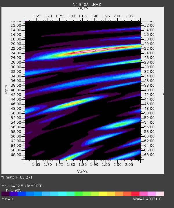
| Estimated Moho Depth: |
22.5 km |
| Estimated Crust Vp/Vs: |
1.90 |
| Assumed Crust Vp: |
6.571 km/s |
| Estimated Crust Vs: |
3.449 km/s |
| Estimated Crust Poisson's Ratio: |
0.31 |
|
| Radial Match: |
83.271 % |
| Radial Bump: |
289 |
| Transverse Match: |
52.087326 % |
| Transverse Bump: |
381 |
| SOD ConfigId: |
626651 |
| Insert Time: |
2014-06-18 12:26:01.980 +0000 |
| GWidth: |
2.5 |
| Max Bumps: |
400 |
| Tol: |
0.001 |
|

Signal To Noise
| Channel | StoN | STA | LTA |
| N4:G40A: :HHZ:20140604T12:04:44.599994Z | 2.495111 | 1.639721E-7 | 6.571736E-8 |
| N4:G40A: :HHN:20140604T12:04:44.599994Z | 1.6165406 | 1.0628001E-7 | 6.574535E-8 |
| N4:G40A: :HHE:20140604T12:04:44.599994Z | 2.2952929 | 1.2009497E-7 | 5.232228E-8 |
| Arrivals |
| Ps | 3.4 SECOND |
| PpPs | 9.2 SECOND |
| PsPs/PpSs | 13 SECOND |


