You are here: Home > Network List > II - Global Seismograph Network (GSN - IRIS/IDA) Stations List
> Station ABKT Alibek, Turkmenistan > Earthquake Result Viewer
ABKT Alibek, Turkmenistan - Earthquake Result Viewer

| Earthquake location: |
Luzon, Philippines |
| Earthquake latitude/longitude: |
13.7/124.5 |
| Earthquake time(UTC): |
1994/10/12 (285) 06:02:50 GMT |
| Earthquake Depth: |
33 km |
| Earthquake Magnitude: |
5.4 MB, 5.7 MS, 5.6 UNKNOWN |
| Earthquake Catalog/Contributor: |
WHDF/NEIC |
|
| Network: |
II Global Seismograph Network (GSN - IRIS/IDA) |
| Station: |
ABKT Alibek, Turkmenistan |
| Lat/Lon: |
37.93 N/58.12 E |
| Elevation: |
678 m |
|
| Distance: |
63.1 deg |
| Az: |
305.669 deg |
| Baz: |
93.295 deg |
| Ray Param: |
0.05971562 |
| Estimated Moho Depth: |
12.5 km |
| Estimated Crust Vp/Vs: |
1.73 |
| Assumed Crust Vp: |
6.53 km/s |
| Estimated Crust Vs: |
3.78 km/s |
| Estimated Crust Poisson's Ratio: |
0.25 |
|
| Radial Match: |
94.242325 % |
| Radial Bump: |
400 |
| Transverse Match: |
91.073906 % |
| Transverse Bump: |
400 |
| SOD ConfigId: |
17000 |
| Insert Time: |
2010-03-01 22:50:36.296 +0000 |
| GWidth: |
2.5 |
| Max Bumps: |
400 |
| Tol: |
0.001 |
|
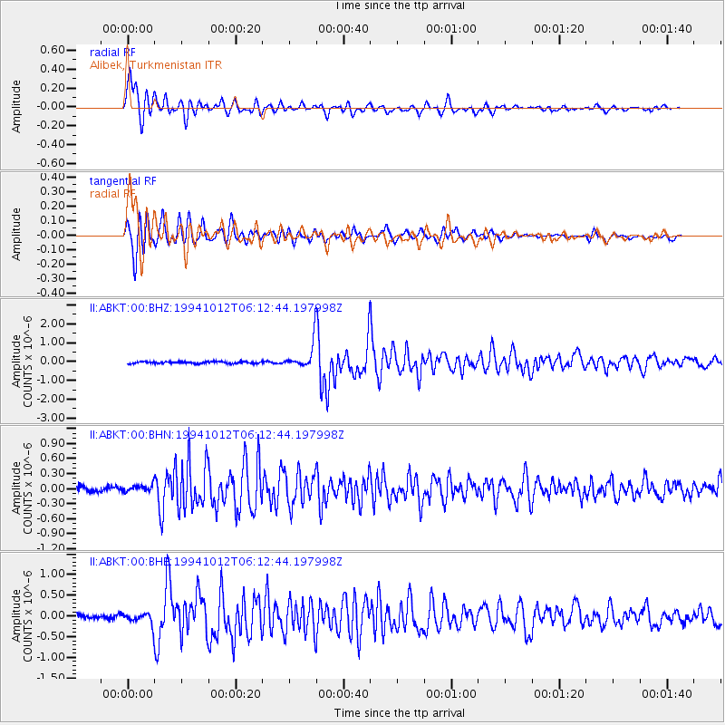
Signal To Noise
| Channel | StoN | STA | LTA |
| II:ABKT:00:BHN:19941012T06:12:44.197998Z | 1.3941778 | 7.012911E-8 | 5.030141E-8 |
| II:ABKT:00:BHE:19941012T06:12:44.197998Z | 2.3517213 | 1.4290372E-7 | 6.0765586E-8 |
| II:ABKT:00:BHZ:19941012T06:12:44.197998Z | 13.69021 | 6.972006E-7 | 5.0926946E-8 |
| Arrivals |
| Ps | 1.5 SECOND |
| PpPs | 5.0 SECOND |
| PsPs/PpSs | 6.4 SECOND |


