You are here: Home > Network List > N4 - Central and EAstern US Network Stations List
> Station N47A Urbana, IN, USA > Earthquake Result Viewer
N47A Urbana, IN, USA - Earthquake Result Viewer
| Earthquake location: |
Southeastern Alaska |
| Earthquake latitude/longitude: |
59.0/-136.7 |
| Earthquake time(UTC): |
2014/06/04 (155) 11:58:58 GMT |
| Earthquake Depth: |
10 km |
| Earthquake Magnitude: |
5.7 MWP, 5.8 ML, 5.8 MI |
| Earthquake Catalog/Contributor: |
NEIC PDE/NEIC COMCAT |
|
| Network: |
N4 Central and EAstern US Network |
| Station: |
N47A Urbana, IN, USA |
| Lat/Lon: |
40.88 N/85.69 W |
| Elevation: |
252 m |
|
| Distance: |
36.4 deg |
| Az: |
96.892 deg |
| Baz: |
317.339 deg |
| Ray Param: |
0.07670824 |
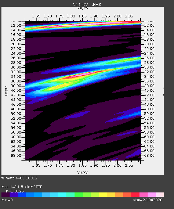
| Estimated Moho Depth: |
11.5 km |
| Estimated Crust Vp/Vs: |
1.81 |
| Assumed Crust Vp: |
6.498 km/s |
| Estimated Crust Vs: |
3.585 km/s |
| Estimated Crust Poisson's Ratio: |
0.28 |
|
| Radial Match: |
85.10312 % |
| Radial Bump: |
319 |
| Transverse Match: |
69.28612 % |
| Transverse Bump: |
400 |
| SOD ConfigId: |
626651 |
| Insert Time: |
2014-06-18 12:30:00.597 +0000 |
| GWidth: |
2.5 |
| Max Bumps: |
400 |
| Tol: |
0.001 |
|

Signal To Noise
| Channel | StoN | STA | LTA |
| N4:N47A: :HHZ:20140604T12:05:31.759998Z | 5.9007673 | 5.896053E-7 | 9.99201E-8 |
| N4:N47A: :HHN:20140604T12:05:31.759998Z | 2.2970245 | 2.1737263E-7 | 9.463227E-8 |
| N4:N47A: :HHE:20140604T12:05:31.759998Z | 2.543713 | 1.9299344E-7 | 7.587076E-8 |
| Arrivals |
| Ps | 1.5 SECOND |
| PpPs | 4.6 SECOND |
| PsPs/PpSs | 6.2 SECOND |


