You are here: Home > Network List > NI - North-East Italy Broadband Network Stations List
> Station DRE Drenchia > Earthquake Result Viewer
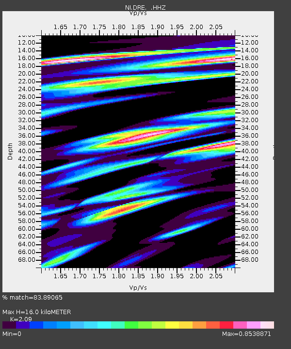
DRE Drenchia - Earthquake Result Viewer
| Earthquake location: |
Southeastern Alaska |
| Earthquake latitude/longitude: |
59.0/-136.7 |
| Earthquake time(UTC): |
2014/06/04 (155) 11:58:58 GMT |
| Earthquake Depth: |
10 km |
| Earthquake Magnitude: |
5.7 MWP, 5.8 ML, 5.8 MI |
| Earthquake Catalog/Contributor: |
NEIC PDE/NEIC COMCAT |
|
| Network: |
NI North-East Italy Broadband Network |
| Station: |
DRE Drenchia |
| Lat/Lon: |
46.17 N/13.65 E |
| Elevation: |
810 m |
|
| Distance: |
72.4 deg |
| Az: |
21.177 deg |
| Baz: |
344.391 deg |
| Ray Param: |
0.053705584 |
| Estimated Moho Depth: |
16.0 km |
| Estimated Crust Vp/Vs: |
2.09 |
| Assumed Crust Vp: |
6.35 km/s |
| Estimated Crust Vs: |
3.038 km/s |
| Estimated Crust Poisson's Ratio: |
0.35 |
|
| Radial Match: |
83.89065 % |
| Radial Bump: |
400 |
| Transverse Match: |
67.84081 % |
| Transverse Bump: |
400 |
| SOD ConfigId: |
626651 |
| Insert Time: |
2014-06-18 12:31:20.468 +0000 |
| GWidth: |
2.5 |
| Max Bumps: |
400 |
| Tol: |
0.001 |
|

Signal To Noise
| Channel | StoN | STA | LTA |
| NI:DRE: :HHZ:20140604T12:09:52.947986Z | 10.562744 | 6.0536405E-7 | 5.7311247E-8 |
| NI:DRE: :HHN:20140604T12:09:52.947986Z | 10.097397 | 3.5823334E-7 | 3.5477793E-8 |
| NI:DRE: :HHE:20140604T12:09:52.947986Z | 3.9935415 | 1.7924268E-7 | 4.4883137E-8 |
| Arrivals |
| Ps | 2.8 SECOND |
| PpPs | 7.6 SECOND |
| PsPs/PpSs | 10 SECOND |


