You are here: Home > Network List > OK - Oklahoma Seismic Network Stations List
> Station QUOK Quay, Oklahoma > Earthquake Result Viewer
QUOK Quay, Oklahoma - Earthquake Result Viewer
| Earthquake location: |
Southeastern Alaska |
| Earthquake latitude/longitude: |
59.0/-136.7 |
| Earthquake time(UTC): |
2014/06/04 (155) 11:58:58 GMT |
| Earthquake Depth: |
10 km |
| Earthquake Magnitude: |
5.7 MWP, 5.8 ML, 5.8 MI |
| Earthquake Catalog/Contributor: |
NEIC PDE/NEIC COMCAT |
|
| Network: |
OK Oklahoma Seismic Network |
| Station: |
QUOK Quay, Oklahoma |
| Lat/Lon: |
36.17 N/96.71 W |
| Elevation: |
296 m |
|
| Distance: |
34.5 deg |
| Az: |
113.566 deg |
| Baz: |
324.104 deg |
| Ray Param: |
0.077694945 |
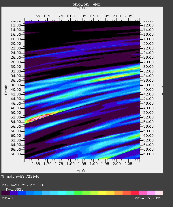
| Estimated Moho Depth: |
51.75 km |
| Estimated Crust Vp/Vs: |
1.66 |
| Assumed Crust Vp: |
6.483 km/s |
| Estimated Crust Vs: |
3.899 km/s |
| Estimated Crust Poisson's Ratio: |
0.22 |
|
| Radial Match: |
83.722946 % |
| Radial Bump: |
400 |
| Transverse Match: |
70.59701 % |
| Transverse Bump: |
400 |
| SOD ConfigId: |
626651 |
| Insert Time: |
2014-06-18 12:33:36.183 +0000 |
| GWidth: |
2.5 |
| Max Bumps: |
400 |
| Tol: |
0.001 |
|

Signal To Noise
| Channel | StoN | STA | LTA |
| OK:QUOK: :HHZ:20140604T12:05:15.823993Z | 2.510578 | 7.438963E-7 | 2.9630482E-7 |
| OK:QUOK: :HHN:20140604T12:05:15.823993Z | 3.642833 | 7.280576E-7 | 1.9986028E-7 |
| OK:QUOK: :HHE:20140604T12:05:15.823993Z | 1.1850579 | 4.0627648E-7 | 3.428326E-7 |
| Arrivals |
| Ps | 5.8 SECOND |
| PpPs | 20 SECOND |
| PsPs/PpSs | 25 SECOND |


