You are here: Home > Network List > TA - USArray Transportable Network (new EarthScope stations) Stations List
> Station E51A G1948 Merrick Township, ON, CAN > Earthquake Result Viewer
E51A G1948 Merrick Township, ON, CAN - Earthquake Result Viewer
| Earthquake location: |
Southeastern Alaska |
| Earthquake latitude/longitude: |
59.0/-136.7 |
| Earthquake time(UTC): |
2014/06/04 (155) 11:58:58 GMT |
| Earthquake Depth: |
10 km |
| Earthquake Magnitude: |
5.7 MWP, 5.8 ML, 5.8 MI |
| Earthquake Catalog/Contributor: |
NEIC PDE/NEIC COMCAT |
|
| Network: |
TA USArray Transportable Network (new EarthScope stations) |
| Station: |
E51A G1948 Merrick Township, ON, CAN |
| Lat/Lon: |
46.53 N/79.49 W |
| Elevation: |
369 m |
|
| Distance: |
35.6 deg |
| Az: |
84.667 deg |
| Baz: |
311.714 deg |
| Ray Param: |
0.07711876 |
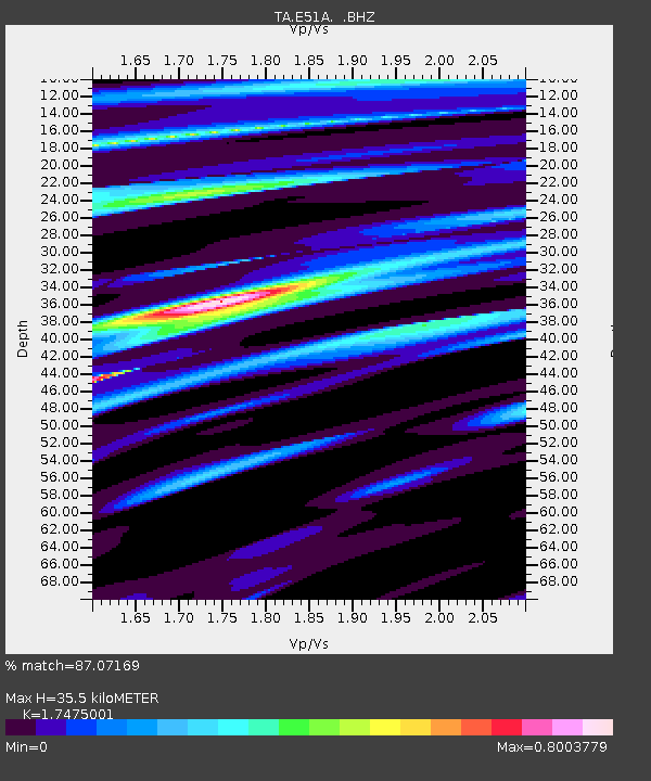
| Estimated Moho Depth: |
35.5 km |
| Estimated Crust Vp/Vs: |
1.75 |
| Assumed Crust Vp: |
6.622 km/s |
| Estimated Crust Vs: |
3.79 km/s |
| Estimated Crust Poisson's Ratio: |
0.26 |
|
| Radial Match: |
87.07169 % |
| Radial Bump: |
368 |
| Transverse Match: |
68.164856 % |
| Transverse Bump: |
386 |
| SOD ConfigId: |
626651 |
| Insert Time: |
2014-06-18 12:39:00.115 +0000 |
| GWidth: |
2.5 |
| Max Bumps: |
400 |
| Tol: |
0.001 |
|
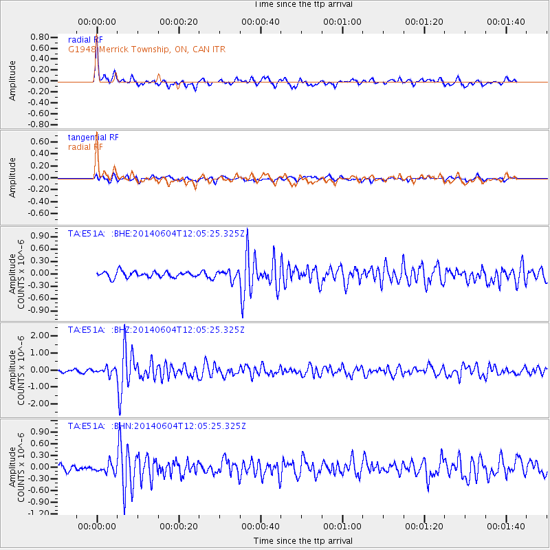
Signal To Noise
| Channel | StoN | STA | LTA |
| TA:E51A: :BHZ:20140604T12:05:25.325Z | 2.6524494 | 1.8595618E-7 | 7.010734E-8 |
| TA:E51A: :BHN:20140604T12:05:25.325Z | 1.2707283 | 1.2071833E-7 | 9.4999315E-8 |
| TA:E51A: :BHE:20140604T12:05:25.325Z | 1.5341856 | 1.077815E-7 | 7.025323E-8 |
| Arrivals |
| Ps | 4.3 SECOND |
| PpPs | 14 SECOND |
| PsPs/PpSs | 18 SECOND |


