You are here: Home > Network List > TA - USArray Transportable Network (new EarthScope stations) Stations List
> Station H48A Harrisville, MI, USA > Earthquake Result Viewer
H48A Harrisville, MI, USA - Earthquake Result Viewer
| Earthquake location: |
Southeastern Alaska |
| Earthquake latitude/longitude: |
59.0/-136.7 |
| Earthquake time(UTC): |
2014/06/04 (155) 11:58:58 GMT |
| Earthquake Depth: |
10 km |
| Earthquake Magnitude: |
5.7 MWP, 5.8 ML, 5.8 MI |
| Earthquake Catalog/Contributor: |
NEIC PDE/NEIC COMCAT |
|
| Network: |
TA USArray Transportable Network (new EarthScope stations) |
| Station: |
H48A Harrisville, MI, USA |
| Lat/Lon: |
44.70 N/83.32 W |
| Elevation: |
244 m |
|
| Distance: |
34.9 deg |
| Az: |
90.158 deg |
| Baz: |
313.468 deg |
| Ray Param: |
0.07750733 |
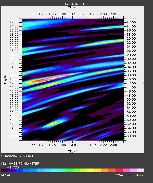
| Estimated Moho Depth: |
38.75 km |
| Estimated Crust Vp/Vs: |
1.77 |
| Assumed Crust Vp: |
6.483 km/s |
| Estimated Crust Vs: |
3.652 km/s |
| Estimated Crust Poisson's Ratio: |
0.27 |
|
| Radial Match: |
87.63043 % |
| Radial Bump: |
400 |
| Transverse Match: |
67.98982 % |
| Transverse Bump: |
400 |
| SOD ConfigId: |
626651 |
| Insert Time: |
2014-06-18 12:41:04.879 +0000 |
| GWidth: |
2.5 |
| Max Bumps: |
400 |
| Tol: |
0.001 |
|

Signal To Noise
| Channel | StoN | STA | LTA |
| TA:H48A: :BHZ:20140604T12:05:18.950Z | 2.0049813 | 3.830304E-7 | 1.9103939E-7 |
| TA:H48A: :BHN:20140604T12:05:18.950Z | 1.5995543 | 3.0798415E-7 | 1.9254372E-7 |
| TA:H48A: :BHE:20140604T12:05:18.950Z | 1.2013617 | 2.735045E-7 | 2.2766207E-7 |
| Arrivals |
| Ps | 5.0 SECOND |
| PpPs | 15 SECOND |
| PsPs/PpSs | 20 SECOND |


