You are here: Home > Network List > GS - US Geological Survey Networks Stations List
> Station KAN13 Rinehart Farm > Earthquake Result Viewer
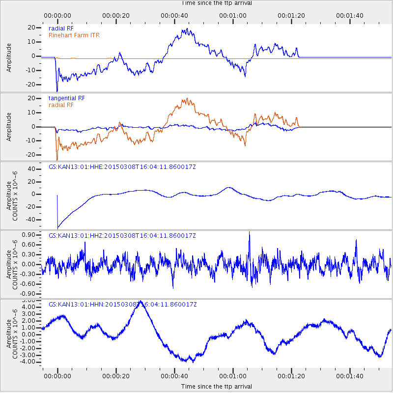
KAN13 Rinehart Farm - Earthquake Result Viewer
*The percent match for this event was below the threshold and hence no stack was calculated.
| Earthquake location: |
Fiji Islands Region |
| Earthquake latitude/longitude: |
-20.1/-177.8 |
| Earthquake time(UTC): |
2015/03/08 (067) 15:52:22 GMT |
| Earthquake Depth: |
558 km |
| Earthquake Magnitude: |
5.5 MW |
| Earthquake Catalog/Contributor: |
ISC/ISC |
|
| Network: |
GS US Geological Survey Networks |
| Station: |
KAN13 Rinehart Farm |
| Lat/Lon: |
37.01 N/97.48 W |
| Elevation: |
340 m |
|
| Distance: |
94.5 deg |
| Az: |
52.321 deg |
| Baz: |
248.356 deg |
| Ray Param: |
$rayparam |
*The percent match for this event was below the threshold and hence was not used in the summary stack. |
|
| Radial Match: |
41.12247 % |
| Radial Bump: |
400 |
| Transverse Match: |
25.685392 % |
| Transverse Bump: |
400 |
| SOD ConfigId: |
7019011 |
| Insert Time: |
2019-04-17 06:10:57.494 +0000 |
| GWidth: |
2.5 |
| Max Bumps: |
400 |
| Tol: |
0.001 |
|
Signal To Noise
| Channel | StoN | STA | LTA |
| GS:KAN13:01:HHZ:20150308T16:04:11.860017Z | 1.2414474 | 1.6861796E-7 | 1.3582367E-7 |
| GS:KAN13:01:HHN:20150308T16:04:11.860017Z | 2.1508071 | 5.1745797E-6 | 2.4058781E-6 |
| GS:KAN13:01:HHE:20150308T16:04:11.860017Z | 1.0780542 | 1.7943185E-5 | 1.6644048E-5 |
| Arrivals |
| Ps | |
| PpPs | |
| PsPs/PpSs | |


