You are here: Home > Network List > TA - USArray Transportable Network (new EarthScope stations) Stations List
> Station J57A Williamstown, NY, USA > Earthquake Result Viewer
J57A Williamstown, NY, USA - Earthquake Result Viewer
| Earthquake location: |
Southeastern Alaska |
| Earthquake latitude/longitude: |
59.0/-136.7 |
| Earthquake time(UTC): |
2014/06/04 (155) 11:58:58 GMT |
| Earthquake Depth: |
10 km |
| Earthquake Magnitude: |
5.7 MWP, 5.8 ML, 5.8 MI |
| Earthquake Catalog/Contributor: |
NEIC PDE/NEIC COMCAT |
|
| Network: |
TA USArray Transportable Network (new EarthScope stations) |
| Station: |
J57A Williamstown, NY, USA |
| Lat/Lon: |
43.41 N/76.00 W |
| Elevation: |
191 m |
|
| Distance: |
39.6 deg |
| Az: |
85.6 deg |
| Baz: |
314.917 deg |
| Ray Param: |
0.074902445 |
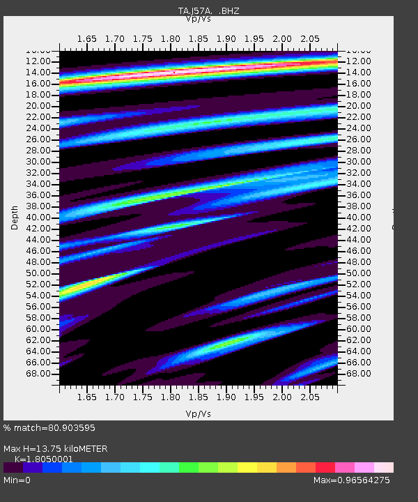
| Estimated Moho Depth: |
13.75 km |
| Estimated Crust Vp/Vs: |
1.81 |
| Assumed Crust Vp: |
6.419 km/s |
| Estimated Crust Vs: |
3.556 km/s |
| Estimated Crust Poisson's Ratio: |
0.28 |
|
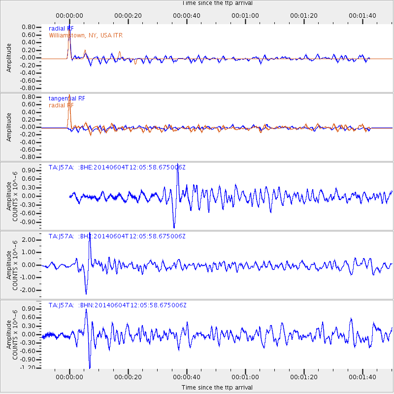
| Radial Match: |
80.903595 % |
| Radial Bump: |
321 |
| Transverse Match: |
66.69121 % |
| Transverse Bump: |
400 |
| SOD ConfigId: |
626651 |
| Insert Time: |
2014-06-18 12:43:09.696 +0000 |
| GWidth: |
2.5 |
| Max Bumps: |
400 |
| Tol: |
0.001 |
|
Signal To Noise
| Channel | StoN | STA | LTA |
| TA:J57A: :BHZ:20140604T12:05:58.675006Z | 3.6295266 | 2.549048E-7 | 7.023087E-8 |
| TA:J57A: :BHN:20140604T12:05:58.675006Z | 2.1978939 | 1.4286132E-7 | 6.499919E-8 |
| TA:J57A: :BHE:20140604T12:05:58.675006Z | 1.7218136 | 1.5495071E-7 | 8.999273E-8 |
| Arrivals |
| Ps | 1.8 SECOND |
| PpPs | 5.6 SECOND |
| PsPs/PpSs | 7.5 SECOND |


