You are here: Home > Network List > II - Global Seismograph Network (GSN - IRIS/IDA) Stations List
> Station ABKT Alibek, Turkmenistan > Earthquake Result Viewer
ABKT Alibek, Turkmenistan - Earthquake Result Viewer

| Earthquake location: |
Timor Region |
| Earthquake latitude/longitude: |
-8.4/125.1 |
| Earthquake time(UTC): |
1995/05/14 (134) 11:33:21 GMT |
| Earthquake Depth: |
33 km |
| Earthquake Magnitude: |
6.1 MB, 6.9 MS, 7.1 UNKNOWN, 6.9 MW |
| Earthquake Catalog/Contributor: |
WHDF/NEIC |
|
| Network: |
II Global Seismograph Network (GSN - IRIS/IDA) |
| Station: |
ABKT Alibek, Turkmenistan |
| Lat/Lon: |
37.93 N/58.12 E |
| Elevation: |
678 m |
|
| Distance: |
77.4 deg |
| Az: |
311.796 deg |
| Baz: |
111.12 deg |
| Ray Param: |
0.05027074 |
| Estimated Moho Depth: |
10.5 km |
| Estimated Crust Vp/Vs: |
1.88 |
| Assumed Crust Vp: |
6.53 km/s |
| Estimated Crust Vs: |
3.464 km/s |
| Estimated Crust Poisson's Ratio: |
0.30 |
|
| Radial Match: |
94.698555 % |
| Radial Bump: |
400 |
| Transverse Match: |
92.94194 % |
| Transverse Bump: |
400 |
| SOD ConfigId: |
61242 |
| Insert Time: |
2010-03-01 22:51:21.731 +0000 |
| GWidth: |
2.5 |
| Max Bumps: |
400 |
| Tol: |
0.001 |
|
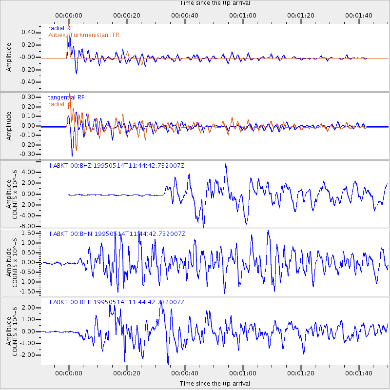
Signal To Noise
| Channel | StoN | STA | LTA |
| II:ABKT:00:BHN:19950514T11:44:42.732007Z | 3.4565783 | 9.0049085E-8 | 2.6051511E-8 |
| II:ABKT:00:BHE:19950514T11:44:42.732007Z | 8.991261 | 1.8616967E-7 | 2.0705624E-8 |
| II:ABKT:00:BHZ:19950514T11:44:42.732007Z | 14.724896 | 6.8714246E-7 | 4.666535E-8 |
| Arrivals |
| Ps | 1.5 SECOND |
| PpPs | 4.5 SECOND |
| PsPs/PpSs | 6.0 SECOND |


