You are here: Home > Network List > TA - USArray Transportable Network (new EarthScope stations) Stations List
> Station J61A Chester, VT, USA > Earthquake Result Viewer
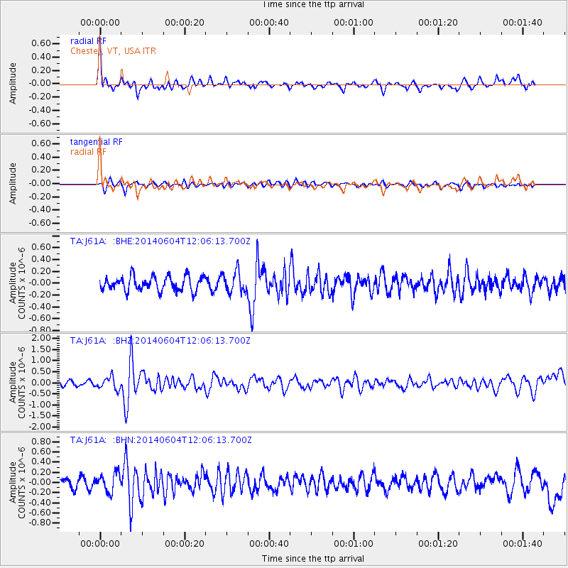
J61A Chester, VT, USA - Earthquake Result Viewer
*The percent match for this event was below the threshold and hence no stack was calculated.
| Earthquake location: |
Southeastern Alaska |
| Earthquake latitude/longitude: |
59.0/-136.7 |
| Earthquake time(UTC): |
2014/06/04 (155) 11:58:58 GMT |
| Earthquake Depth: |
10 km |
| Earthquake Magnitude: |
5.7 MWP, 5.8 ML, 5.8 MI |
| Earthquake Catalog/Contributor: |
NEIC PDE/NEIC COMCAT |
|
| Network: |
TA USArray Transportable Network (new EarthScope stations) |
| Station: |
J61A Chester, VT, USA |
| Lat/Lon: |
43.35 N/72.55 W |
| Elevation: |
253 m |
|
| Distance: |
41.4 deg |
| Az: |
82.931 deg |
| Baz: |
315.244 deg |
| Ray Param: |
$rayparam |
*The percent match for this event was below the threshold and hence was not used in the summary stack. |
|
| Radial Match: |
77.027115 % |
| Radial Bump: |
400 |
| Transverse Match: |
70.467476 % |
| Transverse Bump: |
386 |
| SOD ConfigId: |
626651 |
| Insert Time: |
2014-06-18 12:43:48.595 +0000 |
| GWidth: |
2.5 |
| Max Bumps: |
400 |
| Tol: |
0.001 |
|
Signal To Noise
| Channel | StoN | STA | LTA |
| TA:J61A: :BHZ:20140604T12:06:13.700Z | 2.657199 | 2.7983788E-7 | 1.053131E-7 |
| TA:J61A: :BHN:20140604T12:06:13.700Z | 1.6479349 | 1.8604194E-7 | 1.12893986E-7 |
| TA:J61A: :BHE:20140604T12:06:13.700Z | 1.47507 | 1.7904831E-7 | 1.2138293E-7 |
| Arrivals |
| Ps | |
| PpPs | |
| PsPs/PpSs | |


