You are here: Home > Network List > TA - USArray Transportable Network (new EarthScope stations) Stations List
> Station M53A WI Miller and Sons, Farmdale, OH, USA > Earthquake Result Viewer
M53A WI Miller and Sons, Farmdale, OH, USA - Earthquake Result Viewer

| Earthquake location: |
Southeastern Alaska |
| Earthquake latitude/longitude: |
59.0/-136.7 |
| Earthquake time(UTC): |
2014/06/04 (155) 11:58:58 GMT |
| Earthquake Depth: |
10 km |
| Earthquake Magnitude: |
5.7 MWP, 5.8 ML, 5.8 MI |
| Earthquake Catalog/Contributor: |
NEIC PDE/NEIC COMCAT |
|
| Network: |
TA USArray Transportable Network (new EarthScope stations) |
| Station: |
M53A WI Miller and Sons, Farmdale, OH, USA |
| Lat/Lon: |
41.44 N/80.68 W |
| Elevation: |
334 m |
|
| Distance: |
38.6 deg |
| Az: |
91.715 deg |
| Baz: |
316.521 deg |
| Ray Param: |
0.07548611 |
| Estimated Moho Depth: |
17.75 km |
| Estimated Crust Vp/Vs: |
2.03 |
| Assumed Crust Vp: |
6.483 km/s |
| Estimated Crust Vs: |
3.189 km/s |
| Estimated Crust Poisson's Ratio: |
0.34 |
|
| Radial Match: |
90.877655 % |
| Radial Bump: |
352 |
| Transverse Match: |
80.02395 % |
| Transverse Bump: |
400 |
| SOD ConfigId: |
626651 |
| Insert Time: |
2014-06-18 12:45:46.267 +0000 |
| GWidth: |
2.5 |
| Max Bumps: |
400 |
| Tol: |
0.001 |
|
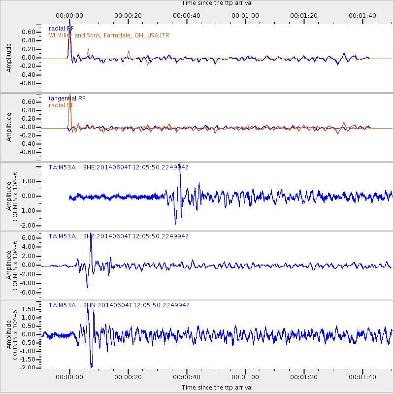
Signal To Noise
| Channel | StoN | STA | LTA |
| TA:M53A: :BHZ:20140604T12:05:50.224994Z | 5.2003455 | 5.597615E-7 | 1.07639295E-7 |
| TA:M53A: :BHN:20140604T12:05:50.224994Z | 2.194303 | 2.7421842E-7 | 1.2496835E-7 |
| TA:M53A: :BHE:20140604T12:05:50.224994Z | 2.5374157 | 2.1152601E-7 | 8.336277E-8 |
| Arrivals |
| Ps | 3.0 SECOND |
| PpPs | 7.8 SECOND |
| PsPs/PpSs | 11 SECOND |


