You are here: Home > Network List > TA - USArray Transportable Network (new EarthScope stations) Stations List
> Station P55A Reedsville, WV, USA > Earthquake Result Viewer
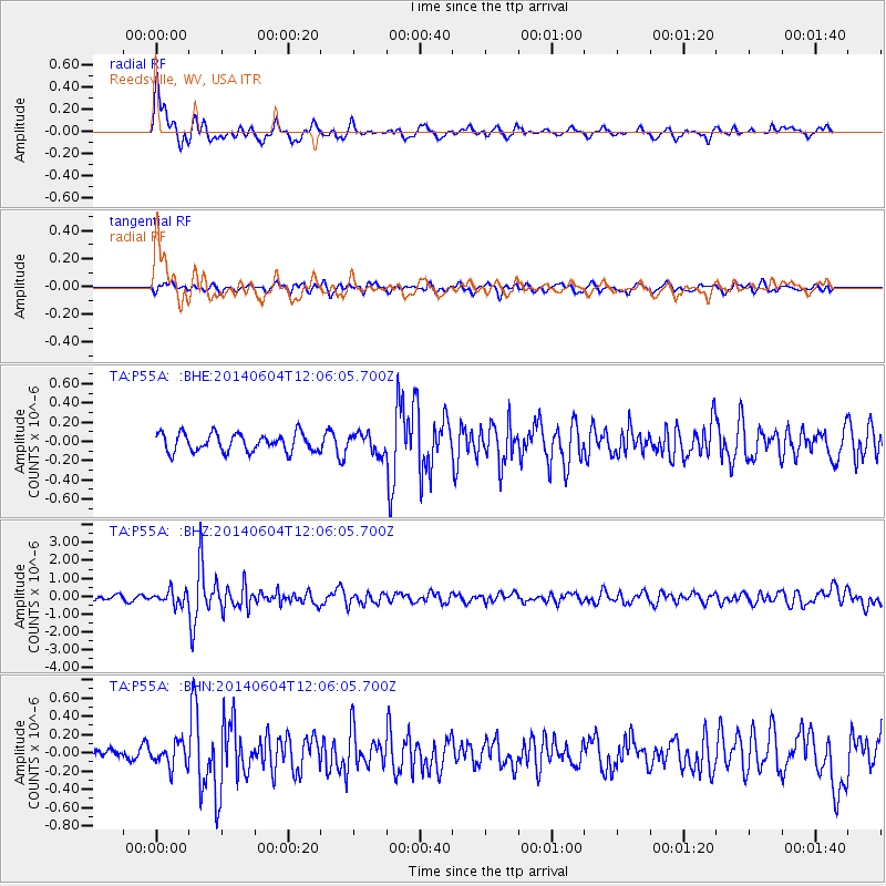
P55A Reedsville, WV, USA - Earthquake Result Viewer

| Earthquake location: |
Southeastern Alaska |
| Earthquake latitude/longitude: |
59.0/-136.7 |
| Earthquake time(UTC): |
2014/06/04 (155) 11:58:58 GMT |
| Earthquake Depth: |
10 km |
| Earthquake Magnitude: |
5.7 MWP, 5.8 ML, 5.8 MI |
| Earthquake Catalog/Contributor: |
NEIC PDE/NEIC COMCAT |
|
| Network: |
TA USArray Transportable Network (new EarthScope stations) |
| Station: |
P55A Reedsville, WV, USA |
| Lat/Lon: |
39.51 N/79.83 W |
| Elevation: |
551 m |
|
| Distance: |
40.4 deg |
| Az: |
93.024 deg |
| Baz: |
318.08 deg |
| Ray Param: |
0.074409194 |
| Estimated Moho Depth: |
38.5 km |
| Estimated Crust Vp/Vs: |
2.10 |
| Assumed Crust Vp: |
6.159 km/s |
| Estimated Crust Vs: |
2.936 km/s |
| Estimated Crust Poisson's Ratio: |
0.35 |
|
| Radial Match: |
82.97489 % |
| Radial Bump: |
400 |
| Transverse Match: |
61.18438 % |
| Transverse Bump: |
400 |
| SOD ConfigId: |
626651 |
| Insert Time: |
2014-06-18 12:48:25.419 +0000 |
| GWidth: |
2.5 |
| Max Bumps: |
400 |
| Tol: |
0.001 |
|
Signal To Noise
| Channel | StoN | STA | LTA |
| TA:P55A: :BHZ:20140604T12:06:05.700Z | 2.2634702 | 3.845967E-7 | 1.6991463E-7 |
| TA:P55A: :BHN:20140604T12:06:05.700Z | 1.3262217 | 1.3049737E-7 | 9.839785E-8 |
| TA:P55A: :BHE:20140604T12:06:05.700Z | 1.0935653 | 1.02147794E-7 | 9.340804E-8 |
| Arrivals |
| Ps | 7.2 SECOND |
| PpPs | 18 SECOND |
| PsPs/PpSs | 26 SECOND |


