You are here: Home > Network List > TA - USArray Transportable Network (new EarthScope stations) Stations List
> Station S56A Natural Bridge, VA, USA > Earthquake Result Viewer
S56A Natural Bridge, VA, USA - Earthquake Result Viewer
| Earthquake location: |
Southeastern Alaska |
| Earthquake latitude/longitude: |
59.0/-136.7 |
| Earthquake time(UTC): |
2014/06/04 (155) 11:58:58 GMT |
| Earthquake Depth: |
10 km |
| Earthquake Magnitude: |
5.7 MWP, 5.8 ML, 5.8 MI |
| Earthquake Catalog/Contributor: |
NEIC PDE/NEIC COMCAT |
|
| Network: |
TA USArray Transportable Network (new EarthScope stations) |
| Station: |
S56A Natural Bridge, VA, USA |
| Lat/Lon: |
37.68 N/79.57 W |
| Elevation: |
449 m |
|
| Distance: |
41.9 deg |
| Az: |
94.621 deg |
| Baz: |
319.444 deg |
| Ray Param: |
0.07347582 |
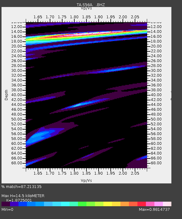
| Estimated Moho Depth: |
14.5 km |
| Estimated Crust Vp/Vs: |
1.87 |
| Assumed Crust Vp: |
6.419 km/s |
| Estimated Crust Vs: |
3.428 km/s |
| Estimated Crust Poisson's Ratio: |
0.30 |
|
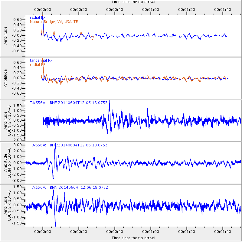
| Radial Match: |
87.213135 % |
| Radial Bump: |
352 |
| Transverse Match: |
72.660774 % |
| Transverse Bump: |
400 |
| SOD ConfigId: |
626651 |
| Insert Time: |
2014-06-18 12:49:54.383 +0000 |
| GWidth: |
2.5 |
| Max Bumps: |
400 |
| Tol: |
0.001 |
|
Signal To Noise
| Channel | StoN | STA | LTA |
| TA:S56A: :BHZ:20140604T12:06:18.075Z | 2.7897499 | 4.4014772E-7 | 1.5777317E-7 |
| TA:S56A: :BHN:20140604T12:06:18.075Z | 1.2706097 | 2.4688993E-7 | 1.9430823E-7 |
| TA:S56A: :BHE:20140604T12:06:18.075Z | 1.3045707 | 2.5296228E-7 | 1.9390461E-7 |
| Arrivals |
| Ps | 2.1 SECOND |
| PpPs | 6.1 SECOND |
| PsPs/PpSs | 8.2 SECOND |


