You are here: Home > Network List > YN10 - San Jacinto Fault Zone Stations List
> Station GVAR1 GVAR1, Anza, CA, USA > Earthquake Result Viewer
GVAR1 GVAR1, Anza, CA, USA - Earthquake Result Viewer
| Earthquake location: |
Fiji Islands Region |
| Earthquake latitude/longitude: |
-20.1/-177.8 |
| Earthquake time(UTC): |
2015/03/08 (067) 15:52:22 GMT |
| Earthquake Depth: |
558 km |
| Earthquake Magnitude: |
5.5 MW |
| Earthquake Catalog/Contributor: |
ISC/ISC |
|
| Network: |
YN San Jacinto Fault Zone |
| Station: |
GVAR1 GVAR1, Anza, CA, USA |
| Lat/Lon: |
33.67 N/116.71 W |
| Elevation: |
1328 m |
|
| Distance: |
79.0 deg |
| Az: |
48.05 deg |
| Baz: |
236.963 deg |
| Ray Param: |
0.04755337 |
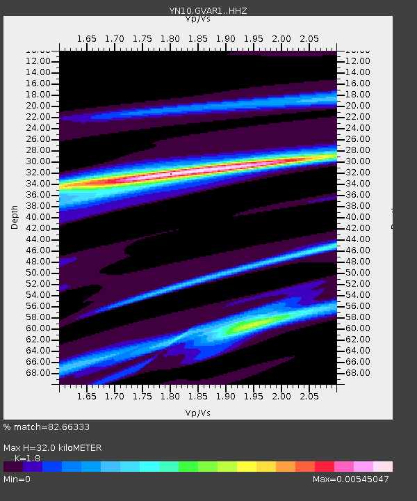
| Estimated Moho Depth: |
32.0 km |
| Estimated Crust Vp/Vs: |
1.80 |
| Assumed Crust Vp: |
6.264 km/s |
| Estimated Crust Vs: |
3.48 km/s |
| Estimated Crust Poisson's Ratio: |
0.28 |
|
| Radial Match: |
82.66333 % |
| Radial Bump: |
319 |
| Transverse Match: |
39.510765 % |
| Transverse Bump: |
340 |
| SOD ConfigId: |
7019011 |
| Insert Time: |
2019-04-17 06:14:30.822 +0000 |
| GWidth: |
2.5 |
| Max Bumps: |
400 |
| Tol: |
0.001 |
|

Signal To Noise
| Channel | StoN | STA | LTA |
| YN:GVAR1: :HHZ:20150308T16:02:57.813997Z | 1.928719 | 1.8382161E-4 | 9.530761E-5 |
| YN:GVAR1: :HHN:20150308T16:02:57.813997Z | 1.2713925 | 1.1879774E-6 | 9.343908E-7 |
| YN:GVAR1: :HHE:20150308T16:02:57.813997Z | 1.1274824 | 2.0053157E-7 | 1.7785781E-7 |
| Arrivals |
| Ps | 4.2 SECOND |
| PpPs | 14 SECOND |
| PsPs/PpSs | 18 SECOND |


