You are here: Home > Network List > TA - USArray Transportable Network (new EarthScope stations) Stations List
> Station T54A Tazewell, VA, USA > Earthquake Result Viewer
T54A Tazewell, VA, USA - Earthquake Result Viewer
| Earthquake location: |
Southeastern Alaska |
| Earthquake latitude/longitude: |
59.0/-136.7 |
| Earthquake time(UTC): |
2014/06/04 (155) 11:58:58 GMT |
| Earthquake Depth: |
10 km |
| Earthquake Magnitude: |
5.7 MWP, 5.8 ML, 5.8 MI |
| Earthquake Catalog/Contributor: |
NEIC PDE/NEIC COMCAT |
|
| Network: |
TA USArray Transportable Network (new EarthScope stations) |
| Station: |
T54A Tazewell, VA, USA |
| Lat/Lon: |
37.06 N/81.58 W |
| Elevation: |
852 m |
|
| Distance: |
41.4 deg |
| Az: |
97.058 deg |
| Baz: |
320.05 deg |
| Ray Param: |
0.07383486 |
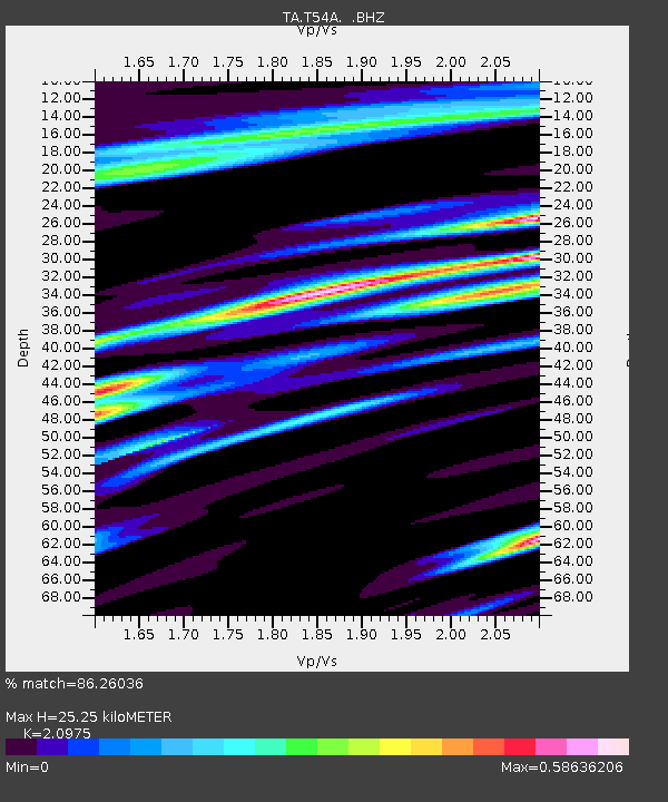
| Estimated Moho Depth: |
25.25 km |
| Estimated Crust Vp/Vs: |
2.10 |
| Assumed Crust Vp: |
6.159 km/s |
| Estimated Crust Vs: |
2.936 km/s |
| Estimated Crust Poisson's Ratio: |
0.35 |
|
| Radial Match: |
86.26036 % |
| Radial Bump: |
249 |
| Transverse Match: |
58.615753 % |
| Transverse Bump: |
400 |
| SOD ConfigId: |
626651 |
| Insert Time: |
2014-06-18 12:50:18.409 +0000 |
| GWidth: |
2.5 |
| Max Bumps: |
400 |
| Tol: |
0.001 |
|
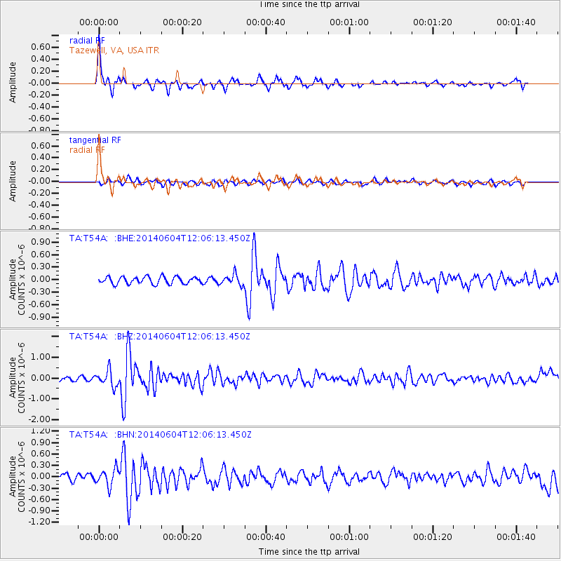
Signal To Noise
| Channel | StoN | STA | LTA |
| TA:T54A: :BHZ:20140604T12:06:13.450Z | 3.0295336 | 3.890146E-7 | 1.2840742E-7 |
| TA:T54A: :BHN:20140604T12:06:13.450Z | 2.9620306 | 2.2530979E-7 | 7.6065994E-8 |
| TA:T54A: :BHE:20140604T12:06:13.450Z | 1.5416336 | 1.2997384E-7 | 8.4309164E-8 |
| Arrivals |
| Ps | 4.7 SECOND |
| PpPs | 12 SECOND |
| PsPs/PpSs | 17 SECOND |


