You are here: Home > Network List > TA - USArray Transportable Network (new EarthScope stations) Stations List
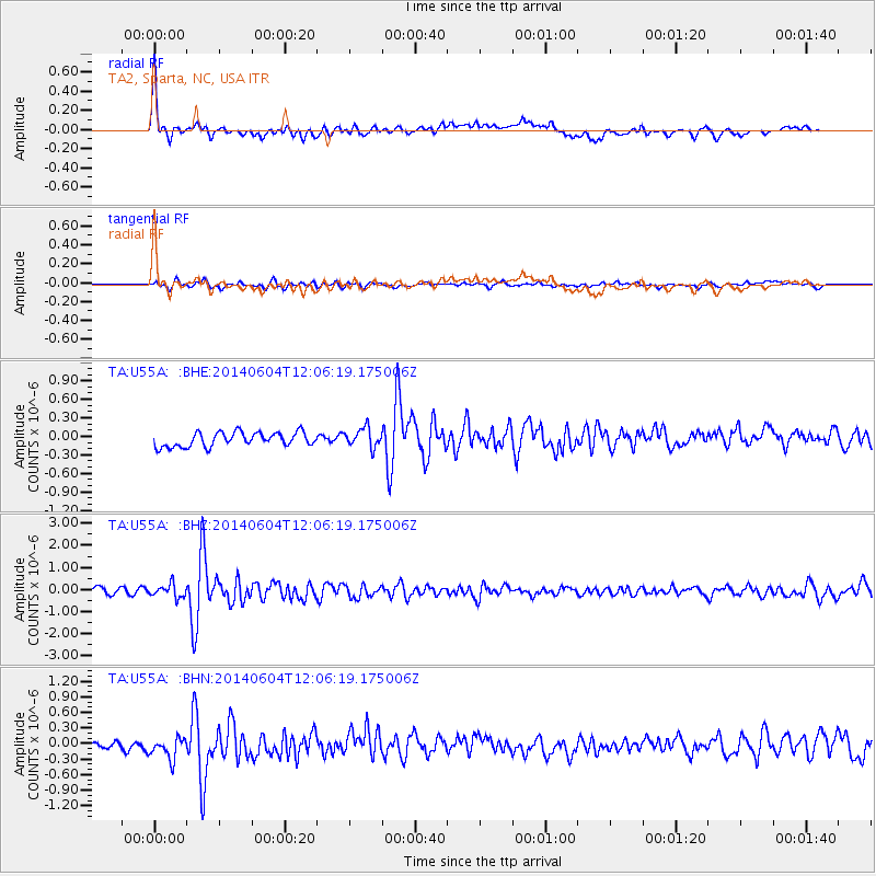
> Station U55A TA2, Sparta, NC, USA > Earthquake Result Viewer
U55A TA2, Sparta, NC, USA - Earthquake Result Viewer
| Earthquake location: |
Southeastern Alaska |
| Earthquake latitude/longitude: |
59.0/-136.7 |
| Earthquake time(UTC): |
2014/06/04 (155) 11:58:58 GMT |
| Earthquake Depth: |
10 km |
| Earthquake Magnitude: |
5.7 MWP, 5.8 ML, 5.8 MI |
| Earthquake Catalog/Contributor: |
NEIC PDE/NEIC COMCAT |
|
| Network: |
TA USArray Transportable Network (new EarthScope stations) |
| Station: |
U55A TA2, Sparta, NC, USA |
| Lat/Lon: |
36.50 N/81.05 W |
| Elevation: |
863 m |
|
| Distance: |
42.1 deg |
| Az: |
97.104 deg |
| Baz: |
320.399 deg |
| Ray Param: |
0.07338947 |
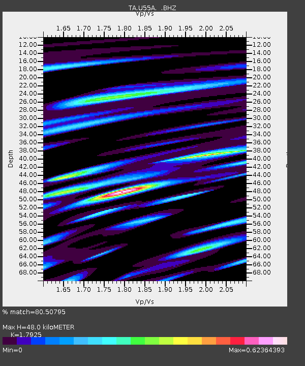
| Estimated Moho Depth: |
48.0 km |
| Estimated Crust Vp/Vs: |
1.79 |
| Assumed Crust Vp: |
6.159 km/s |
| Estimated Crust Vs: |
3.436 km/s |
| Estimated Crust Poisson's Ratio: |
0.27 |
|
| Radial Match: |
80.50795 % |
| Radial Bump: |
400 |
| Transverse Match: |
69.74525 % |
| Transverse Bump: |
400 |
| SOD ConfigId: |
626651 |
| Insert Time: |
2014-06-18 12:50:53.768 +0000 |
| GWidth: |
2.5 |
| Max Bumps: |
400 |
| Tol: |
0.001 |
|
Signal To Noise
| Channel | StoN | STA | LTA |
| TA:U55A: :BHZ:20140604T12:06:19.175006Z | 2.1080067 | 2.9624988E-7 | 1.4053555E-7 |
| TA:U55A: :BHN:20140604T12:06:19.175006Z | 1.9745613 | 2.2064206E-7 | 1.11742324E-7 |
| TA:U55A: :BHE:20140604T12:06:19.175006Z | 1.3665142 | 1.5691948E-7 | 1.1483195E-7 |
| Arrivals |
| Ps | 6.6 SECOND |
| PpPs | 20 SECOND |
| PsPs/PpSs | 27 SECOND |


