You are here: Home > Network List > TA - USArray Transportable Network (new EarthScope stations) Stations List
> Station W56A Indian Trail, NC, USA > Earthquake Result Viewer
W56A Indian Trail, NC, USA - Earthquake Result Viewer
| Earthquake location: |
Southeastern Alaska |
| Earthquake latitude/longitude: |
59.0/-136.7 |
| Earthquake time(UTC): |
2014/06/04 (155) 11:58:58 GMT |
| Earthquake Depth: |
10 km |
| Earthquake Magnitude: |
5.7 MWP, 5.8 ML, 5.8 MI |
| Earthquake Catalog/Contributor: |
NEIC PDE/NEIC COMCAT |
|
| Network: |
TA USArray Transportable Network (new EarthScope stations) |
| Station: |
W56A Indian Trail, NC, USA |
| Lat/Lon: |
35.13 N/80.58 W |
| Elevation: |
177 m |
|
| Distance: |
43.4 deg |
| Az: |
97.942 deg |
| Baz: |
321.286 deg |
| Ray Param: |
0.07259855 |
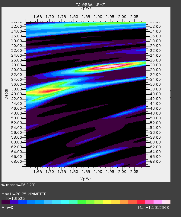
| Estimated Moho Depth: |
28.25 km |
| Estimated Crust Vp/Vs: |
1.95 |
| Assumed Crust Vp: |
6.419 km/s |
| Estimated Crust Vs: |
3.288 km/s |
| Estimated Crust Poisson's Ratio: |
0.32 |
|
| Radial Match: |
86.1281 % |
| Radial Bump: |
268 |
| Transverse Match: |
74.07545 % |
| Transverse Bump: |
400 |
| SOD ConfigId: |
626651 |
| Insert Time: |
2014-06-18 12:51:31.777 +0000 |
| GWidth: |
2.5 |
| Max Bumps: |
400 |
| Tol: |
0.001 |
|

Signal To Noise
| Channel | StoN | STA | LTA |
| TA:W56A: :BHZ:20140604T12:06:29.700Z | 3.97198 | 5.144199E-7 | 1.2951222E-7 |
| TA:W56A: :BHN:20140604T12:06:29.700Z | 4.350573 | 2.6126108E-7 | 6.00521E-8 |
| TA:W56A: :BHE:20140604T12:06:29.700Z | 2.2758915 | 2.3883632E-7 | 1.0494187E-7 |
| Arrivals |
| Ps | 4.5 SECOND |
| PpPs | 12 SECOND |
| PsPs/PpSs | 17 SECOND |


