You are here: Home > Network List > TA - USArray Transportable Network (new EarthScope stations) Stations List
> Station Z41A Richland Creek Farm, El Dorado, AR, USA > Earthquake Result Viewer
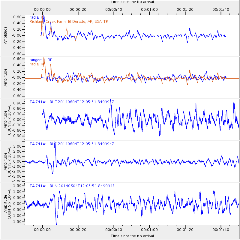
Z41A Richland Creek Farm, El Dorado, AR, USA - Earthquake Result Viewer
*The percent match for this event was below the threshold and hence no stack was calculated.
| Earthquake location: |
Southeastern Alaska |
| Earthquake latitude/longitude: |
59.0/-136.7 |
| Earthquake time(UTC): |
2014/06/04 (155) 11:58:58 GMT |
| Earthquake Depth: |
10 km |
| Earthquake Magnitude: |
5.7 MWP, 5.8 ML, 5.8 MI |
| Earthquake Catalog/Contributor: |
NEIC PDE/NEIC COMCAT |
|
| Network: |
TA USArray Transportable Network (new EarthScope stations) |
| Station: |
Z41A Richland Creek Farm, El Dorado, AR, USA |
| Lat/Lon: |
33.26 N/92.80 W |
| Elevation: |
62 m |
|
| Distance: |
38.8 deg |
| Az: |
111.995 deg |
| Baz: |
325.057 deg |
| Ray Param: |
$rayparam |
*The percent match for this event was below the threshold and hence was not used in the summary stack. |
|
| Radial Match: |
76.9653 % |
| Radial Bump: |
400 |
| Transverse Match: |
69.49756 % |
| Transverse Bump: |
400 |
| SOD ConfigId: |
626651 |
| Insert Time: |
2014-06-18 12:52:22.951 +0000 |
| GWidth: |
2.5 |
| Max Bumps: |
400 |
| Tol: |
0.001 |
|
Signal To Noise
| Channel | StoN | STA | LTA |
| TA:Z41A: :BHZ:20140604T12:05:51.849994Z | 5.268789 | 5.3900186E-7 | 1.0230091E-7 |
| TA:Z41A: :BHN:20140604T12:05:51.849994Z | 1.3083361 | 1.9678343E-7 | 1.5040739E-7 |
| TA:Z41A: :BHE:20140604T12:05:51.849994Z | 0.8069539 | 1.5471375E-7 | 1.9172562E-7 |
| Arrivals |
| Ps | |
| PpPs | |
| PsPs/PpSs | |


