You are here: Home > Network List > TA - USArray Transportable Network (new EarthScope stations) Stations List
> Station Z56A Williston, SC, USA > Earthquake Result Viewer
Z56A Williston, SC, USA - Earthquake Result Viewer

| Earthquake location: |
Southeastern Alaska |
| Earthquake latitude/longitude: |
59.0/-136.7 |
| Earthquake time(UTC): |
2014/06/04 (155) 11:58:58 GMT |
| Earthquake Depth: |
10 km |
| Earthquake Magnitude: |
5.7 MWP, 5.8 ML, 5.8 MI |
| Earthquake Catalog/Contributor: |
NEIC PDE/NEIC COMCAT |
|
| Network: |
TA USArray Transportable Network (new EarthScope stations) |
| Station: |
Z56A Williston, SC, USA |
| Lat/Lon: |
33.33 N/81.37 W |
| Elevation: |
81 m |
|
| Distance: |
44.4 deg |
| Az: |
100.288 deg |
| Baz: |
322.537 deg |
| Ray Param: |
0.071948774 |
| Estimated Moho Depth: |
23.25 km |
| Estimated Crust Vp/Vs: |
1.63 |
| Assumed Crust Vp: |
6.565 km/s |
| Estimated Crust Vs: |
4.027 km/s |
| Estimated Crust Poisson's Ratio: |
0.20 |
|
| Radial Match: |
82.382904 % |
| Radial Bump: |
400 |
| Transverse Match: |
71.954155 % |
| Transverse Bump: |
400 |
| SOD ConfigId: |
626651 |
| Insert Time: |
2014-06-18 12:52:26.966 +0000 |
| GWidth: |
2.5 |
| Max Bumps: |
400 |
| Tol: |
0.001 |
|
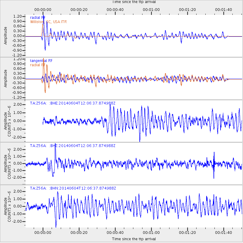
Signal To Noise
| Channel | StoN | STA | LTA |
| TA:Z56A: :BHZ:20140604T12:06:37.874988Z | 3.0114393 | 4.519838E-7 | 1.5008895E-7 |
| TA:Z56A: :BHN:20140604T12:06:37.874988Z | 1.5697968 | 4.145219E-7 | 2.6406087E-7 |
| TA:Z56A: :BHE:20140604T12:06:37.874988Z | 1.4117515 | 2.948881E-7 | 2.0888103E-7 |
| Arrivals |
| Ps | 2.4 SECOND |
| PpPs | 8.6 SECOND |
| PsPs/PpSs | 11 SECOND |


