You are here: Home > Network List > II - Global Seismograph Network (GSN - IRIS/IDA) Stations List
> Station ABKT Alibek, Turkmenistan > Earthquake Result Viewer
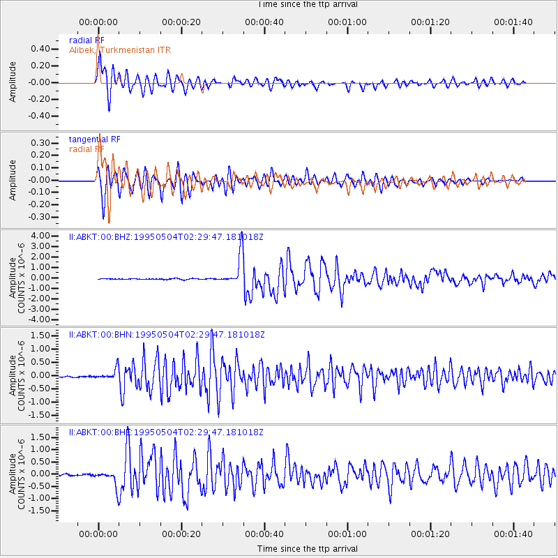
ABKT Alibek, Turkmenistan - Earthquake Result Viewer

| Earthquake location: |
Halmahera, Indonesia |
| Earthquake latitude/longitude: |
1.9/128.5 |
| Earthquake time(UTC): |
1995/05/04 (124) 02:18:51 GMT |
| Earthquake Depth: |
55 km |
| Earthquake Magnitude: |
6.0 MB, 6.0 MS, 6.1 UNKNOWN, 6.1 MW |
| Earthquake Catalog/Contributor: |
WHDF/NEIC |
|
| Network: |
II Global Seismograph Network (GSN - IRIS/IDA) |
| Station: |
ABKT Alibek, Turkmenistan |
| Lat/Lon: |
37.93 N/58.12 E |
| Elevation: |
678 m |
|
| Distance: |
73.4 deg |
| Az: |
309.007 deg |
| Baz: |
100.83 deg |
| Ray Param: |
0.052901186 |
| Estimated Moho Depth: |
20.5 km |
| Estimated Crust Vp/Vs: |
2.09 |
| Assumed Crust Vp: |
6.53 km/s |
| Estimated Crust Vs: |
3.125 km/s |
| Estimated Crust Poisson's Ratio: |
0.35 |
|
| Radial Match: |
95.200096 % |
| Radial Bump: |
400 |
| Transverse Match: |
94.14342 % |
| Transverse Bump: |
400 |
| SOD ConfigId: |
6273 |
| Insert Time: |
2010-03-01 22:52:03.215 +0000 |
| GWidth: |
2.5 |
| Max Bumps: |
400 |
| Tol: |
0.001 |
|
Signal To Noise
| Channel | StoN | STA | LTA |
| II:ABKT:00:BHN:19950504T02:29:47.181018Z | 9.394605 | 2.0972276E-7 | 2.2323745E-8 |
| II:ABKT:00:BHE:19950504T02:29:47.181018Z | 11.522564 | 3.4334818E-7 | 2.9797897E-8 |
| II:ABKT:00:BHZ:19950504T02:29:47.181018Z | 36.340656 | 1.5632103E-6 | 4.3015465E-8 |
| Arrivals |
| Ps | 3.5 SECOND |
| PpPs | 9.4 SECOND |
| PsPs/PpSs | 13 SECOND |


