You are here: Home > Network List > II - Global Seismograph Network (GSN - IRIS/IDA) Stations List
> Station ABKT Alibek, Turkmenistan > Earthquake Result Viewer
ABKT Alibek, Turkmenistan - Earthquake Result Viewer

| Earthquake location: |
Samar, Philippines |
| Earthquake latitude/longitude: |
12.3/125.0 |
| Earthquake time(UTC): |
1995/07/12 (193) 18:38:49 GMT |
| Earthquake Depth: |
33 km |
| Earthquake Magnitude: |
5.8 MB, 5.6 MS, 5.6 UNKNOWN, 6.0 MW |
| Earthquake Catalog/Contributor: |
WHDF/NEIC |
|
| Network: |
II Global Seismograph Network (GSN - IRIS/IDA) |
| Station: |
ABKT Alibek, Turkmenistan |
| Lat/Lon: |
37.93 N/58.12 E |
| Elevation: |
678 m |
|
| Distance: |
64.4 deg |
| Az: |
306.206 deg |
| Baz: |
94.258 deg |
| Ray Param: |
0.0589191 |
| Estimated Moho Depth: |
29.75 km |
| Estimated Crust Vp/Vs: |
2.07 |
| Assumed Crust Vp: |
6.53 km/s |
| Estimated Crust Vs: |
3.151 km/s |
| Estimated Crust Poisson's Ratio: |
0.35 |
|
| Radial Match: |
95.08529 % |
| Radial Bump: |
400 |
| Transverse Match: |
93.439674 % |
| Transverse Bump: |
400 |
| SOD ConfigId: |
6273 |
| Insert Time: |
2010-03-01 22:52:07.953 +0000 |
| GWidth: |
2.5 |
| Max Bumps: |
400 |
| Tol: |
0.001 |
|
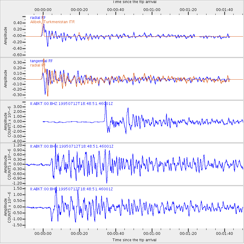
Signal To Noise
| Channel | StoN | STA | LTA |
| II:ABKT:00:BHN:19950712T18:48:51.46001Z | 2.9349189 | 1.0871166E-7 | 3.704077E-8 |
| II:ABKT:00:BHE:19950712T18:48:51.46001Z | 7.692106 | 2.9879652E-7 | 3.8844565E-8 |
| II:ABKT:00:BHZ:19950712T18:48:51.46001Z | 19.12853 | 1.1790004E-6 | 6.1635696E-8 |
| Arrivals |
| Ps | 5.1 SECOND |
| PpPs | 13 SECOND |
| PsPs/PpSs | 19 SECOND |


