You are here: Home > Network List > II - Global Seismograph Network (GSN - IRIS/IDA) Stations List
> Station ABKT Alibek, Turkmenistan > Earthquake Result Viewer
ABKT Alibek, Turkmenistan - Earthquake Result Viewer
| Earthquake location: |
Northern Molucca Sea |
| Earthquake latitude/longitude: |
2.6/127.7 |
| Earthquake time(UTC): |
1995/07/26 (207) 23:42:02 GMT |
| Earthquake Depth: |
66 km |
| Earthquake Magnitude: |
5.9 MB, 6.4 UNKNOWN, 6.4 MW |
| Earthquake Catalog/Contributor: |
WHDF/NEIC |
|
| Network: |
II Global Seismograph Network (GSN - IRIS/IDA) |
| Station: |
ABKT Alibek, Turkmenistan |
| Lat/Lon: |
37.93 N/58.12 E |
| Elevation: |
678 m |
|
| Distance: |
72.4 deg |
| Az: |
308.963 deg |
| Baz: |
100.784 deg |
| Ray Param: |
0.053564135 |
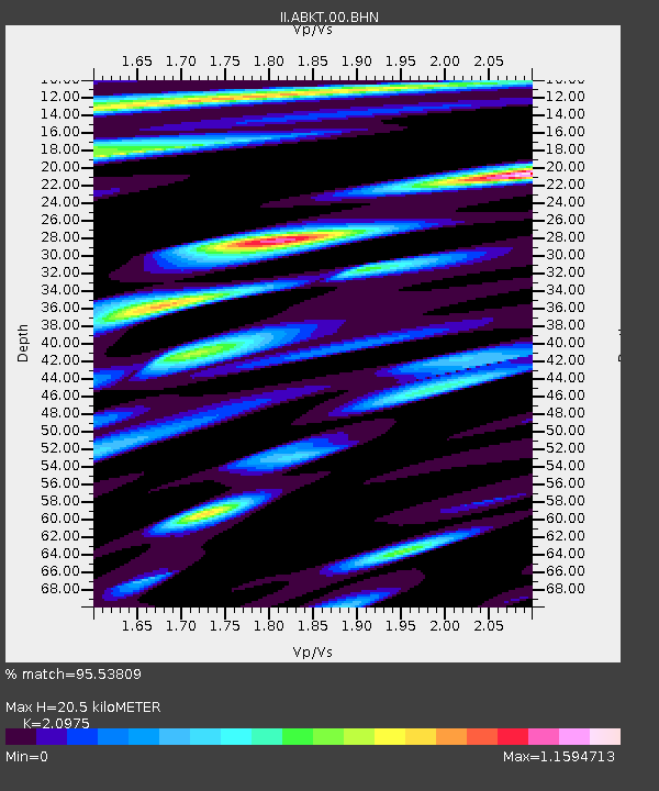
| Estimated Moho Depth: |
20.5 km |
| Estimated Crust Vp/Vs: |
2.10 |
| Assumed Crust Vp: |
6.53 km/s |
| Estimated Crust Vs: |
3.113 km/s |
| Estimated Crust Poisson's Ratio: |
0.35 |
|
| Radial Match: |
95.53809 % |
| Radial Bump: |
400 |
| Transverse Match: |
92.902435 % |
| Transverse Bump: |
400 |
| SOD ConfigId: |
6273 |
| Insert Time: |
2010-03-01 22:52:09.443 +0000 |
| GWidth: |
2.5 |
| Max Bumps: |
400 |
| Tol: |
0.001 |
|

Signal To Noise
| Channel | StoN | STA | LTA |
| II:ABKT:00:BHN:19950726T23:52:50.618005Z | 1.6863191 | 3.5954407E-8 | 2.1321235E-8 |
| II:ABKT:00:BHE:19950726T23:52:50.62002Z | 1.5918112 | 6.339434E-8 | 3.982529E-8 |
| II:ABKT:00:BHZ:19950726T23:52:50.618005Z | 7.674254 | 2.8896213E-7 | 3.765345E-8 |
| Arrivals |
| Ps | 3.6 SECOND |
| PpPs | 9.4 SECOND |
| PsPs/PpSs | 13 SECOND |


