You are here: Home > Network List > II - Global Seismograph Network (GSN - IRIS/IDA) Stations List
> Station ABKT Alibek, Turkmenistan > Earthquake Result Viewer
ABKT Alibek, Turkmenistan - Earthquake Result Viewer
| Earthquake location: |
Kuril Islands |
| Earthquake latitude/longitude: |
45.3/149.9 |
| Earthquake time(UTC): |
1996/02/07 (038) 21:36:45 GMT |
| Earthquake Depth: |
33 km |
| Earthquake Magnitude: |
6.3 MB, 7.0 MS, 7.2 UNKNOWN, 7.1 MW |
| Earthquake Catalog/Contributor: |
WHDF/NEIC |
|
| Network: |
II Global Seismograph Network (GSN - IRIS/IDA) |
| Station: |
ABKT Alibek, Turkmenistan |
| Lat/Lon: |
37.93 N/58.12 E |
| Elevation: |
678 m |
|
| Distance: |
65.4 deg |
| Az: |
299.621 deg |
| Baz: |
50.86 deg |
| Ray Param: |
0.058248222 |
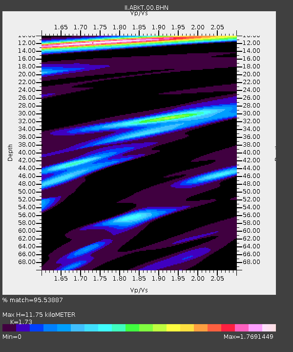
| Estimated Moho Depth: |
11.75 km |
| Estimated Crust Vp/Vs: |
1.73 |
| Assumed Crust Vp: |
6.53 km/s |
| Estimated Crust Vs: |
3.775 km/s |
| Estimated Crust Poisson's Ratio: |
0.25 |
|
| Radial Match: |
95.53887 % |
| Radial Bump: |
400 |
| Transverse Match: |
82.677 % |
| Transverse Bump: |
400 |
| SOD ConfigId: |
6273 |
| Insert Time: |
2010-03-01 22:52:11.939 +0000 |
| GWidth: |
2.5 |
| Max Bumps: |
400 |
| Tol: |
0.001 |
|
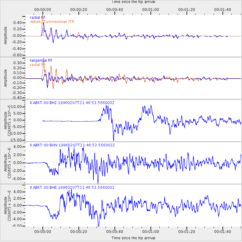
Signal To Noise
| Channel | StoN | STA | LTA |
| II:ABKT:00:BHN:19960207T21:46:53.566003Z | 15.210175 | 9.897774E-7 | 6.507337E-8 |
| II:ABKT:00:BHE:19960207T21:46:53.566003Z | 15.771543 | 1.3625806E-6 | 8.639489E-8 |
| II:ABKT:00:BHZ:19960207T21:46:53.566003Z | 36.31584 | 4.4814706E-6 | 1.2340264E-7 |
| Arrivals |
| Ps | 1.4 SECOND |
| PpPs | 4.7 SECOND |
| PsPs/PpSs | 6.1 SECOND |


