You are here: Home > Network List > IU - Global Seismograph Network (GSN - IRIS/USGS) Stations List
> Station RSSD Black Hills, South Dakota, USA > Earthquake Result Viewer
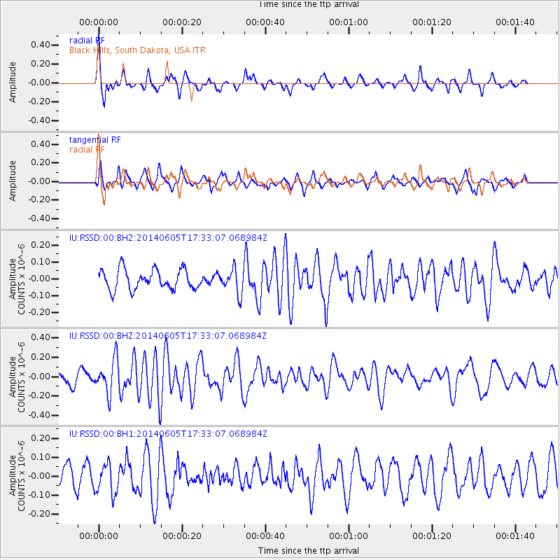
RSSD Black Hills, South Dakota, USA - Earthquake Result Viewer
*The percent match for this event was below the threshold and hence no stack was calculated.
| Earthquake location: |
Easter Island Region |
| Earthquake latitude/longitude: |
-28.9/-112.3 |
| Earthquake time(UTC): |
2014/06/05 (156) 17:22:07 GMT |
| Earthquake Depth: |
7.7 km |
| Earthquake Magnitude: |
5.7 MWB |
| Earthquake Catalog/Contributor: |
NEIC PDE/NEIC COMCAT |
|
| Network: |
IU Global Seismograph Network (GSN - IRIS/USGS) |
| Station: |
RSSD Black Hills, South Dakota, USA |
| Lat/Lon: |
44.12 N/104.04 W |
| Elevation: |
2090 m |
|
| Distance: |
73.1 deg |
| Az: |
6.215 deg |
| Baz: |
187.574 deg |
| Ray Param: |
$rayparam |
*The percent match for this event was below the threshold and hence was not used in the summary stack. |
|
| Radial Match: |
77.05659 % |
| Radial Bump: |
400 |
| Transverse Match: |
73.074165 % |
| Transverse Bump: |
400 |
| SOD ConfigId: |
626651 |
| Insert Time: |
2014-06-19 17:44:32.475 +0000 |
| GWidth: |
2.5 |
| Max Bumps: |
400 |
| Tol: |
0.001 |
|
Signal To Noise
| Channel | StoN | STA | LTA |
| IU:RSSD:00:BHZ:20140605T17:33:07.068984Z | 2.2493773 | 1.7988836E-7 | 7.9972516E-8 |
| IU:RSSD:00:BH1:20140605T17:33:07.068984Z | 1.1028043 | 7.9508425E-8 | 7.209659E-8 |
| IU:RSSD:00:BH2:20140605T17:33:07.068984Z | 1.2509488 | 7.338526E-8 | 5.866368E-8 |
| Arrivals |
| Ps | |
| PpPs | |
| PsPs/PpSs | |


