ABKT Alibek, Turkmenistan - Earthquake Result Viewer
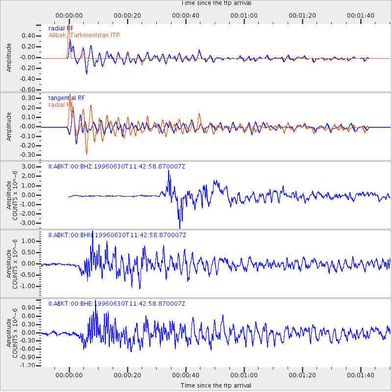
Earthquake location: Off East Coast Of Kamchatka
Earthquake latitude/longitude: 51.7/159.8
Earthquake time(UTC): 1996/06/30 (182) 11:32:35 GMT
Earthquake Depth: 33 km
Earthquake Magnitude: 5.5 MB, 5.9 MS, 6.1 UNKNOWN, 6.0 MW
Earthquake Catalog/Contributor: WHDF/NEIC
Network: II Global Seismograph Network (GSN - IRIS/IDA)
Station: ABKT Alibek, Turkmenistan
Lat/Lon: 37.93 N/58.12 E
Elevation: 678 m
Distance: 67.7 deg
Az: 303.175 deg
Baz: 41.175 deg
Ray Param: 0.05674194
Estimated Moho Depth: 12.25 km
Estimated Crust Vp/Vs: 1.68
Assumed Crust Vp: 6.53 km/s
Estimated Crust Vs: 3.881 km/s
Estimated Crust Poisson's Ratio: 0.23
Radial Match: 94.94064 %
Radial Bump: 400
Transverse Match: 90.096924 %
Transverse Bump: 400
SOD ConfigId: 6273
Insert Time: 2010-03-01 22:52:34.184 +0000
GWidth: 2.5
Max Bumps: 400
Tol: 0.001

Signal To Noise

ChannelStoNSTALTA
II:ABKT:00:BHN:19960630T11:42:58.870007Z5.244361.5357577E-72.9283985E-8
II:ABKT:00:BHE:19960630T11:42:58.870007Z2.73160868.998555E-83.2942328E-8
II:ABKT:00:BHZ:19960630T11:42:58.870007Z23.5733477.756211E-73.290246E-8
Arrivals
Ps1.3 SECOND
PpPs4.8 SECOND
PsPs/PpSs6.2 SECOND