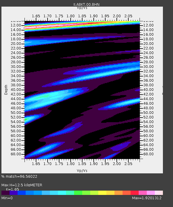
ABKT Alibek, Turkmenistan - Earthquake Result Viewer

Earthquake location: Off East Coast Of Kamchatka
Earthquake latitude/longitude: 51.4/159.2
Earthquake time(UTC): 1996/06/22 (174) 14:50:07 GMT
Earthquake Depth: 33 km
Earthquake Magnitude: 5.6 MB, 6.0 MS, 6.2 UNKNOWN, 6.2 MW
Earthquake Catalog/Contributor: WHDF/NEIC
Network: II Global Seismograph Network (GSN - IRIS/IDA)
Station: ABKT Alibek, Turkmenistan
Lat/Lon: 37.93 N/58.12 E
Elevation: 678 m
Distance: 67.6 deg
Az: 302.921 deg
Baz: 41.684 deg
Ray Param: 0.056820523
Estimated Moho Depth: 12.5 km
Estimated Crust Vp/Vs: 1.65
Assumed Crust Vp: 6.53 km/s
Estimated Crust Vs: 3.958 km/s
Estimated Crust Poisson's Ratio: 0.21
Radial Match: 96.56022 %
Radial Bump: 400
Transverse Match: 85.851074 %
Transverse Bump: 400
SOD ConfigId: 6273
Insert Time: 2010-03-01 22:52:39.280 +0000
GWidth: 2.5
Max Bumps: 400
Tol: 0.001

Signal To Noise

ChannelStoNSTALTA
II:ABKT:00:BHN:19960622T15:00:29.791016Z13.66772653.6372856E-72.6612222E-8
II:ABKT:00:BHE:19960622T15:00:29.791016Z14.4868174.055676E-72.7995629E-8
II:ABKT:00:BHZ:19960622T15:00:29.791016Z31.6989771.3251715E-64.180487E-8
Arrivals
Ps1.3 SECOND
PpPs4.9 SECOND
PsPs/PpSs6.2 SECOND