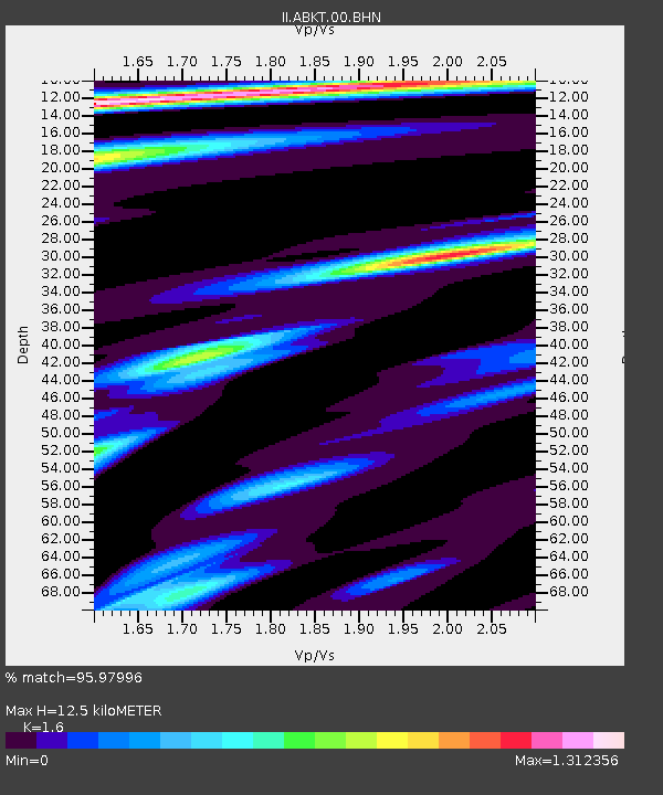
ABKT Alibek, Turkmenistan - Earthquake Result Viewer

Earthquake location: Andreanof Islands, Aleutian Is.
Earthquake latitude/longitude: 51.6/-177.6
Earthquake time(UTC): 1996/06/10 (162) 04:03:35 GMT
Earthquake Depth: 33 km
Earthquake Magnitude: 6.6 MB, 7.6 MS, 7.9 UNKNOWN, 7.4 MS
Earthquake Catalog/Contributor: WHDF/NEIC
Network: II Global Seismograph Network (GSN - IRIS/IDA)
Station: ABKT Alibek, Turkmenistan
Lat/Lon: 37.93 N/58.12 E
Elevation: 678 m
Distance: 78.4 deg
Az: 318.15 deg
Baz: 31.78 deg
Ray Param: 0.04959654
Estimated Moho Depth: 12.5 km
Estimated Crust Vp/Vs: 1.60
Assumed Crust Vp: 6.53 km/s
Estimated Crust Vs: 4.082 km/s
Estimated Crust Poisson's Ratio: 0.18
Radial Match: 95.97996 %
Radial Bump: 400
Transverse Match: 87.988365 %
Transverse Bump: 400
SOD ConfigId: 6273
Insert Time: 2010-03-01 22:52:42.119 +0000
GWidth: 2.5
Max Bumps: 400
Tol: 0.001

Signal To Noise

ChannelStoNSTALTA
II:ABKT:00:BHN:19960610T04:15:01.839026Z3.74144744.2881678E-71.1461253E-7
II:ABKT:00:BHE:19960610T04:15:01.839026Z3.82612422.7196998E-77.1082376E-8
II:ABKT:00:BHZ:19960610T04:15:01.839026Z6.71093652.0112957E-62.9970414E-7
Arrivals
Ps1.2 SECOND
PpPs4.8 SECOND
PsPs/PpSs6.0 SECOND