You are here: Home > Network List > TA - USArray Transportable Network (new EarthScope stations) Stations List
> Station W56A Indian Trail, NC, USA > Earthquake Result Viewer
W56A Indian Trail, NC, USA - Earthquake Result Viewer
*The percent match for this event was below the threshold and hence no stack was calculated.
| Earthquake location: |
Easter Island Region |
| Earthquake latitude/longitude: |
-28.9/-112.3 |
| Earthquake time(UTC): |
2014/06/05 (156) 17:22:07 GMT |
| Earthquake Depth: |
7.7 km |
| Earthquake Magnitude: |
5.7 MWB |
| Earthquake Catalog/Contributor: |
NEIC PDE/NEIC COMCAT |
|
| Network: |
TA USArray Transportable Network (new EarthScope stations) |
| Station: |
W56A Indian Trail, NC, USA |
| Lat/Lon: |
35.13 N/80.58 W |
| Elevation: |
177 m |
|
| Distance: |
70.4 deg |
| Az: |
27.227 deg |
| Baz: |
209.306 deg |
| Ray Param: |
$rayparam |
*The percent match for this event was below the threshold and hence was not used in the summary stack. |
|
| Radial Match: |
64.80967 % |
| Radial Bump: |
400 |
| Transverse Match: |
71.20393 % |
| Transverse Bump: |
400 |
| SOD ConfigId: |
626651 |
| Insert Time: |
2014-06-19 18:02:02.745 +0000 |
| GWidth: |
2.5 |
| Max Bumps: |
400 |
| Tol: |
0.001 |
|
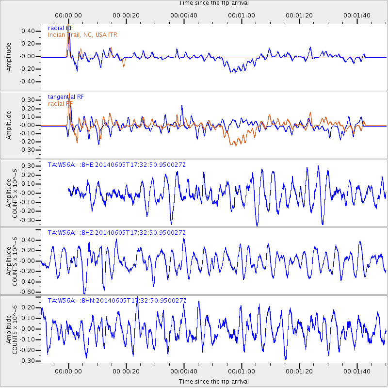
Signal To Noise
| Channel | StoN | STA | LTA |
| TA:W56A: :BHZ:20140605T17:32:50.950027Z | 1.4779161 | 1.4776349E-7 | 9.9980966E-8 |
| TA:W56A: :BHN:20140605T17:32:50.950027Z | 0.5980533 | 7.011401E-8 | 1.1723706E-7 |
| TA:W56A: :BHE:20140605T17:32:50.950027Z | 1.9484681 | 1.1395736E-7 | 5.8485615E-8 |
| Arrivals |
| Ps | |
| PpPs | |
| PsPs/PpSs | |


