You are here: Home > Network List > II - Global Seismograph Network (GSN - IRIS/IDA) Stations List
> Station ABKT Alibek, Turkmenistan > Earthquake Result Viewer
ABKT Alibek, Turkmenistan - Earthquake Result Viewer

| Earthquake location: |
Northern Molucca Sea |
| Earthquake latitude/longitude: |
1.6/126.6 |
| Earthquake time(UTC): |
1996/05/07 (128) 08:44:36 GMT |
| Earthquake Depth: |
33 km |
| Earthquake Magnitude: |
5.9 MB, 5.9 MS, 6.0 UNKNOWN, 5.9 MW |
| Earthquake Catalog/Contributor: |
WHDF/NEIC |
|
| Network: |
II Global Seismograph Network (GSN - IRIS/IDA) |
| Station: |
ABKT Alibek, Turkmenistan |
| Lat/Lon: |
37.93 N/58.12 E |
| Elevation: |
678 m |
|
| Distance: |
72.1 deg |
| Az: |
309.383 deg |
| Baz: |
102.297 deg |
| Ray Param: |
0.053849474 |
| Estimated Moho Depth: |
12.25 km |
| Estimated Crust Vp/Vs: |
1.74 |
| Assumed Crust Vp: |
6.53 km/s |
| Estimated Crust Vs: |
3.753 km/s |
| Estimated Crust Poisson's Ratio: |
0.25 |
|
| Radial Match: |
94.893524 % |
| Radial Bump: |
400 |
| Transverse Match: |
90.50803 % |
| Transverse Bump: |
400 |
| SOD ConfigId: |
6273 |
| Insert Time: |
2010-03-01 22:52:56.141 +0000 |
| GWidth: |
2.5 |
| Max Bumps: |
400 |
| Tol: |
0.001 |
|
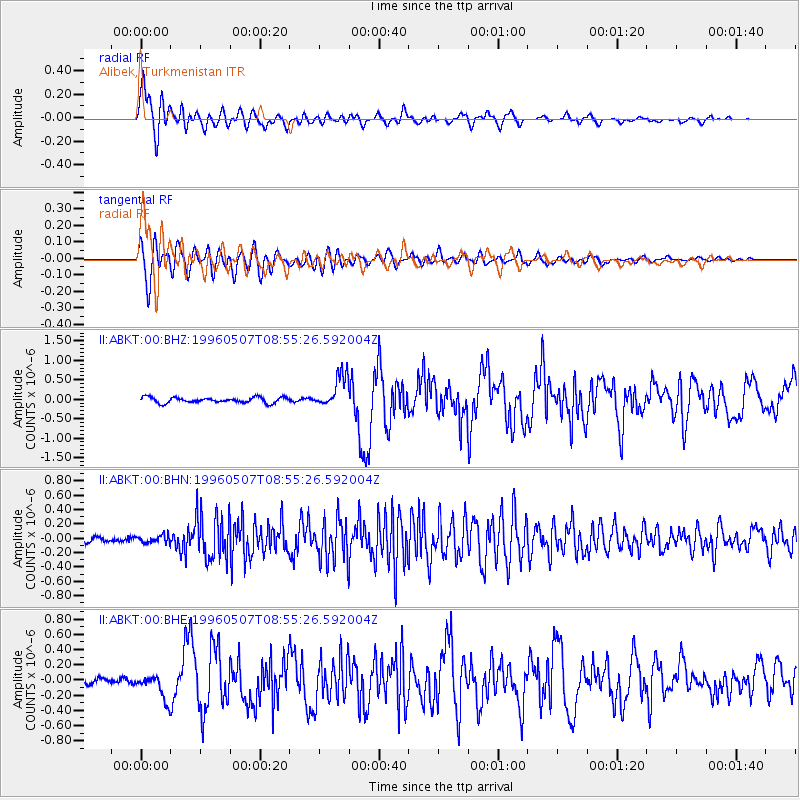
Signal To Noise
| Channel | StoN | STA | LTA |
| II:ABKT:00:BHN:19960507T08:55:26.592004Z | 1.5084802 | 5.1170748E-8 | 3.3922053E-8 |
| II:ABKT:00:BHE:19960507T08:55:26.592004Z | 4.7816067 | 1.6965784E-7 | 3.5481346E-8 |
| II:ABKT:00:BHZ:19960507T08:55:26.592004Z | 6.15856 | 4.26795E-7 | 6.930111E-8 |
| Arrivals |
| Ps | 1.4 SECOND |
| PpPs | 5.0 SECOND |
| PsPs/PpSs | 6.4 SECOND |


