You are here: Home > Network List > US - United States National Seismic Network Stations List
> Station WMOK Wichita Mountains, Oklahoma, USA > Earthquake Result Viewer
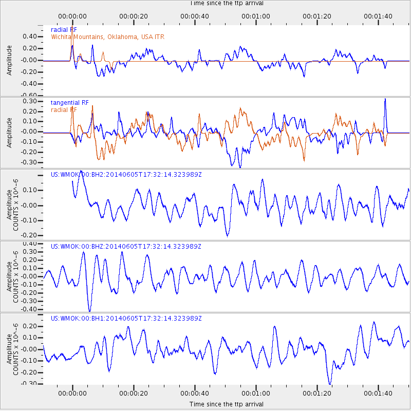
WMOK Wichita Mountains, Oklahoma, USA - Earthquake Result Viewer
*The percent match for this event was below the threshold and hence no stack was calculated.
| Earthquake location: |
Easter Island Region |
| Earthquake latitude/longitude: |
-28.9/-112.3 |
| Earthquake time(UTC): |
2014/06/05 (156) 17:22:07 GMT |
| Earthquake Depth: |
7.7 km |
| Earthquake Magnitude: |
5.7 MWB |
| Earthquake Catalog/Contributor: |
NEIC PDE/NEIC COMCAT |
|
| Network: |
US United States National Seismic Network |
| Station: |
WMOK Wichita Mountains, Oklahoma, USA |
| Lat/Lon: |
34.74 N/98.78 W |
| Elevation: |
486 m |
|
| Distance: |
64.6 deg |
| Az: |
12.311 deg |
| Baz: |
193.122 deg |
| Ray Param: |
$rayparam |
*The percent match for this event was below the threshold and hence was not used in the summary stack. |
|
| Radial Match: |
47.06374 % |
| Radial Bump: |
400 |
| Transverse Match: |
42.593 % |
| Transverse Bump: |
400 |
| SOD ConfigId: |
626651 |
| Insert Time: |
2014-06-19 18:05:22.277 +0000 |
| GWidth: |
2.5 |
| Max Bumps: |
400 |
| Tol: |
0.001 |
|
Signal To Noise
| Channel | StoN | STA | LTA |
| US:WMOK:00:BHZ:20140605T17:32:14.323989Z | 3.0021238 | 1.4552278E-7 | 4.847328E-8 |
| US:WMOK:00:BH1:20140605T17:32:14.323989Z | 0.40665227 | 4.178209E-8 | 1.0274648E-7 |
| US:WMOK:00:BH2:20140605T17:32:14.323989Z | 0.86250156 | 6.798532E-8 | 7.882341E-8 |
| Arrivals |
| Ps | |
| PpPs | |
| PsPs/PpSs | |


