You are here: Home > Network List > CI - Caltech Regional Seismic Network Stations List
> Station VCS Vincent Substation, Palmdale, CA, USA > Earthquake Result Viewer
VCS Vincent Substation, Palmdale, CA, USA - Earthquake Result Viewer
| Earthquake location: |
Near East Coast Of Honshu, Japan |
| Earthquake latitude/longitude: |
38.1/142.1 |
| Earthquake time(UTC): |
2005/12/02 (336) 13:13:09 GMT |
| Earthquake Depth: |
29 km |
| Earthquake Magnitude: |
6.1 MB, 6.3 MS, 6.5 MW, 6.4 MW |
| Earthquake Catalog/Contributor: |
WHDF/NEIC |
|
| Network: |
CI Caltech Regional Seismic Network |
| Station: |
VCS Vincent Substation, Palmdale, CA, USA |
| Lat/Lon: |
34.48 N/118.12 W |
| Elevation: |
991 m |
|
| Distance: |
76.4 deg |
| Az: |
56.899 deg |
| Baz: |
306.852 deg |
| Ray Param: |
0.05100475 |
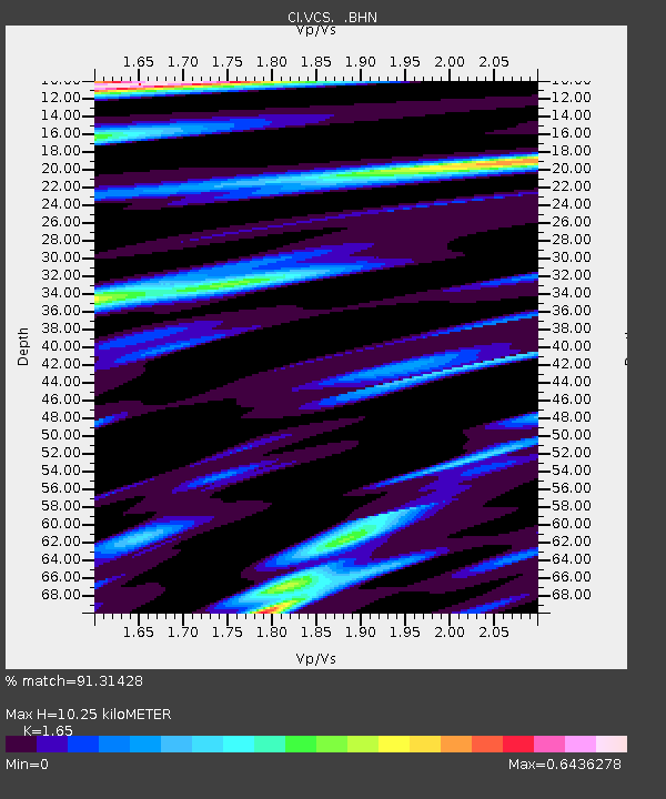
| Estimated Moho Depth: |
10.25 km |
| Estimated Crust Vp/Vs: |
1.65 |
| Assumed Crust Vp: |
6.1 km/s |
| Estimated Crust Vs: |
3.697 km/s |
| Estimated Crust Poisson's Ratio: |
0.21 |
|
| Radial Match: |
91.31428 % |
| Radial Bump: |
400 |
| Transverse Match: |
81.91963 % |
| Transverse Bump: |
400 |
| SOD ConfigId: |
2669 |
| Insert Time: |
2010-02-25 21:07:22.089 +0000 |
| GWidth: |
2.5 |
| Max Bumps: |
400 |
| Tol: |
0.001 |
|
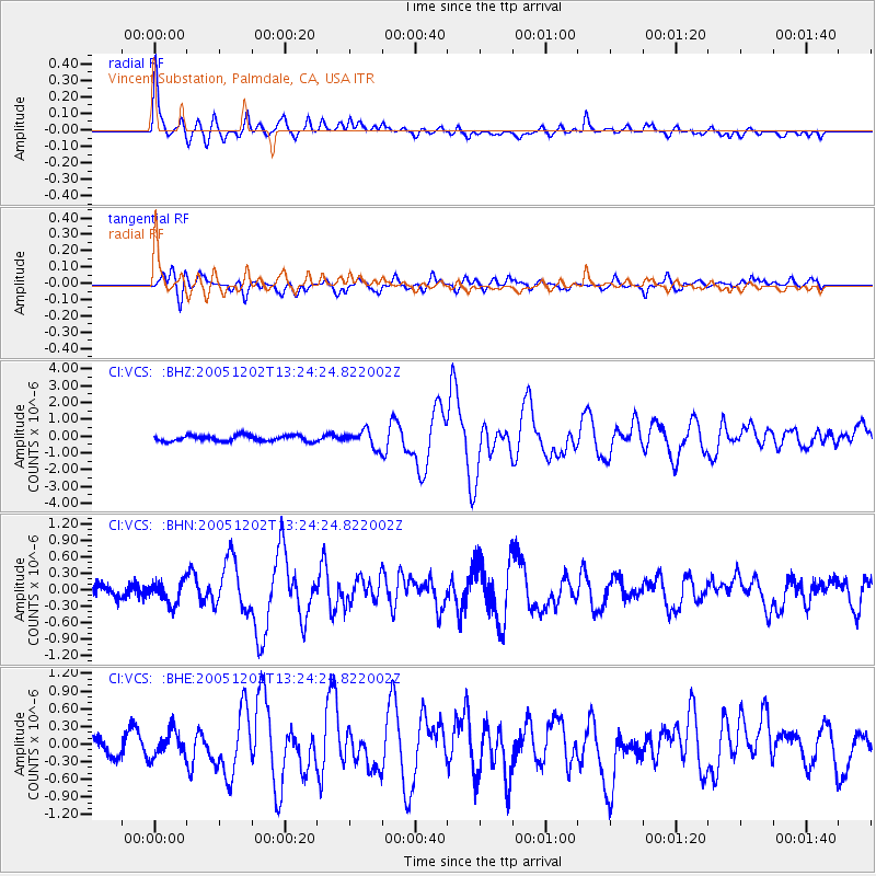
Signal To Noise
| Channel | StoN | STA | LTA |
| CI:VCS: :BHN:20051202T13:24:24.822002Z | 1.195814 | 2.1001817E-7 | 1.756278E-7 |
| CI:VCS: :BHE:20051202T13:24:24.822002Z | 1.2367698 | 2.1969808E-7 | 1.7763861E-7 |
| CI:VCS: :BHZ:20051202T13:24:24.822002Z | 3.020097 | 5.0954543E-7 | 1.6871824E-7 |
| Arrivals |
| Ps | 1.1 SECOND |
| PpPs | 4.3 SECOND |
| PsPs/PpSs | 5.4 SECOND |


