You are here: Home > Network List > II - Global Seismograph Network (GSN - IRIS/IDA) Stations List
> Station ABKT Alibek, Turkmenistan > Earthquake Result Viewer
ABKT Alibek, Turkmenistan - Earthquake Result Viewer

| Earthquake location: |
Samar, Philippines |
| Earthquake latitude/longitude: |
12.8/125.1 |
| Earthquake time(UTC): |
1996/06/14 (166) 15:04:40 GMT |
| Earthquake Depth: |
29 km |
| Earthquake Magnitude: |
5.6 MB, 5.8 MS, 6.1 UNKNOWN, 5.9 MW |
| Earthquake Catalog/Contributor: |
WHDF/NEIC |
|
| Network: |
II Global Seismograph Network (GSN - IRIS/IDA) |
| Station: |
ABKT Alibek, Turkmenistan |
| Lat/Lon: |
37.93 N/58.12 E |
| Elevation: |
678 m |
|
| Distance: |
64.1 deg |
| Az: |
306.013 deg |
| Baz: |
93.805 deg |
| Ray Param: |
0.059107583 |
| Estimated Moho Depth: |
12.75 km |
| Estimated Crust Vp/Vs: |
1.71 |
| Assumed Crust Vp: |
6.53 km/s |
| Estimated Crust Vs: |
3.819 km/s |
| Estimated Crust Poisson's Ratio: |
0.24 |
|
| Radial Match: |
95.62014 % |
| Radial Bump: |
400 |
| Transverse Match: |
92.374275 % |
| Transverse Bump: |
400 |
| SOD ConfigId: |
6273 |
| Insert Time: |
2010-03-01 22:53:04.395 +0000 |
| GWidth: |
2.5 |
| Max Bumps: |
400 |
| Tol: |
0.001 |
|
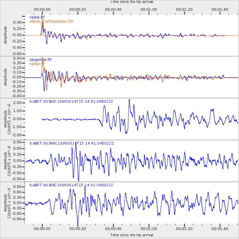
Signal To Noise
| Channel | StoN | STA | LTA |
| II:ABKT:00:BHN:19960614T15:14:41.048022Z | 2.7074122 | 9.857824E-8 | 3.6410505E-8 |
| II:ABKT:00:BHE:19960614T15:14:41.048022Z | 2.4575508 | 1.02704156E-7 | 4.1791264E-8 |
| II:ABKT:00:BHZ:19960614T15:14:41.048022Z | 10.56289 | 5.034684E-7 | 4.766389E-8 |
| Arrivals |
| Ps | 1.5 SECOND |
| PpPs | 5.1 SECOND |
| PsPs/PpSs | 6.5 SECOND |


