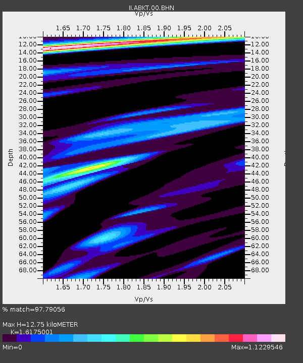
ABKT Alibek, Turkmenistan - Earthquake Result Viewer
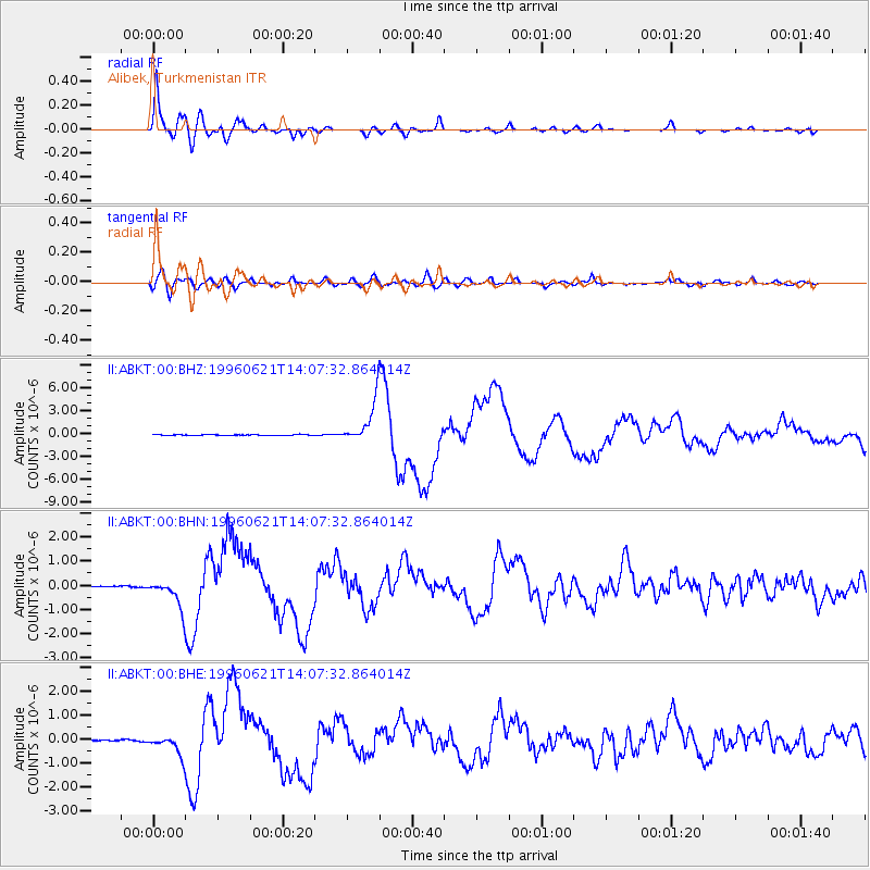
Earthquake location: Off East Coast Of Kamchatka
Earthquake latitude/longitude: 51.6/159.1
Earthquake time(UTC): 1996/06/21 (173) 13:57:10 GMT
Earthquake Depth: 20 km
Earthquake Magnitude: 6.0 MB, 6.6 MS, 7.0 UNKNOWN, 6.5 MS
Earthquake Catalog/Contributor: WHDF/NEIC
Network: II Global Seismograph Network (GSN - IRIS/IDA)
Station: ABKT Alibek, Turkmenistan
Lat/Lon: 37.93 N/58.12 E
Elevation: 678 m
Distance: 67.4 deg
Az: 302.785 deg
Baz: 41.573 deg
Ray Param: 0.05695232
Estimated Moho Depth: 12.75 km
Estimated Crust Vp/Vs: 1.62
Assumed Crust Vp: 6.53 km/s
Estimated Crust Vs: 4.037 km/s
Estimated Crust Poisson's Ratio: 0.19
Radial Match: 97.79056 %
Radial Bump: 400
Transverse Match: 84.96125 %
Transverse Bump: 400
SOD ConfigId: 6273
Insert Time: 2010-03-01 22:53:08.392 +0000
GWidth: 2.5
Max Bumps: 400
Tol: 0.001

Signal To Noise

ChannelStoNSTALTA
II:ABKT:00:BHN:19960621T14:07:32.864014Z9.4412775.51416E-75.8404815E-8
II:ABKT:00:BHE:19960621T14:07:32.864014Z7.49357564.060681E-75.418883E-8
II:ABKT:00:BHZ:19960621T14:07:32.864014Z59.7813762.7603387E-64.6173888E-8
Arrivals
Ps1.3 SECOND
PpPs4.9 SECOND
PsPs/PpSs6.1 SECOND