You are here: Home > Network List > II - Global Seismograph Network (GSN - IRIS/IDA) Stations List
> Station ABKT Alibek, Turkmenistan > Earthquake Result Viewer
ABKT Alibek, Turkmenistan - Earthquake Result Viewer

| Earthquake location: |
Mariana Islands Region |
| Earthquake latitude/longitude: |
22.0/142.8 |
| Earthquake time(UTC): |
1996/07/06 (188) 21:36:28 GMT |
| Earthquake Depth: |
241 km |
| Earthquake Magnitude: |
5.8 MB, 6.3 UNKNOWN, 6.2 MW |
| Earthquake Catalog/Contributor: |
WHDF/NEIC |
|
| Network: |
II Global Seismograph Network (GSN - IRIS/IDA) |
| Station: |
ABKT Alibek, Turkmenistan |
| Lat/Lon: |
37.93 N/58.12 E |
| Elevation: |
678 m |
|
| Distance: |
72.8 deg |
| Az: |
304.498 deg |
| Baz: |
75.344 deg |
| Ray Param: |
0.052743558 |
| Estimated Moho Depth: |
12.75 km |
| Estimated Crust Vp/Vs: |
1.64 |
| Assumed Crust Vp: |
6.53 km/s |
| Estimated Crust Vs: |
3.988 km/s |
| Estimated Crust Poisson's Ratio: |
0.20 |
|
| Radial Match: |
94.58629 % |
| Radial Bump: |
400 |
| Transverse Match: |
86.63419 % |
| Transverse Bump: |
400 |
| SOD ConfigId: |
6273 |
| Insert Time: |
2010-03-01 22:53:10.860 +0000 |
| GWidth: |
2.5 |
| Max Bumps: |
400 |
| Tol: |
0.001 |
|
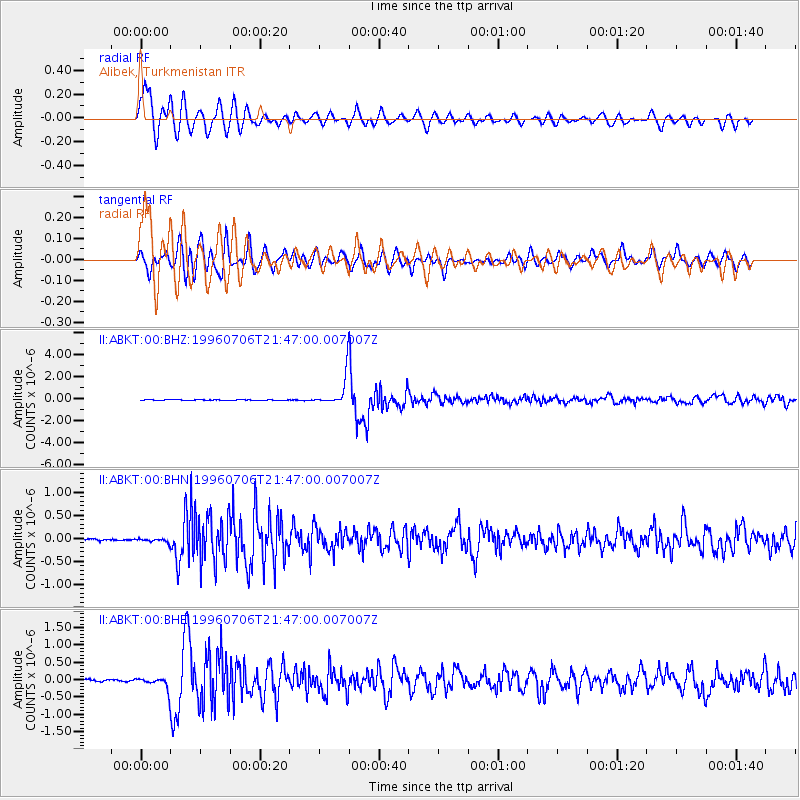
Signal To Noise
| Channel | StoN | STA | LTA |
| II:ABKT:00:BHN:19960706T21:47:00.007007Z | 1.8482147 | 4.4708937E-8 | 2.4190337E-8 |
| II:ABKT:00:BHE:19960706T21:47:00.007007Z | 7.074191 | 1.8878869E-7 | 2.6686966E-8 |
| II:ABKT:00:BHZ:19960706T21:47:00.007007Z | 40.91659 | 1.3175452E-6 | 3.2200756E-8 |
| Arrivals |
| Ps | 1.3 SECOND |
| PpPs | 5.0 SECOND |
| PsPs/PpSs | 6.3 SECOND |


