You are here: Home > Network List > TA - USArray Transportable Network (new EarthScope stations) Stations List
> Station N60A Cedar Hill Farm, Mount Bethel, PA, USA > Earthquake Result Viewer
N60A Cedar Hill Farm, Mount Bethel, PA, USA - Earthquake Result Viewer
*The percent match for this event was below the threshold and hence no stack was calculated.
| Earthquake location: |
South Of Panama |
| Earthquake latitude/longitude: |
6.5/-82.7 |
| Earthquake time(UTC): |
2015/03/09 (068) 02:48:45 GMT |
| Earthquake Depth: |
10 km |
| Earthquake Magnitude: |
5.6 MO |
| Earthquake Catalog/Contributor: |
NEIC PDE/NEIC ALERT |
|
| Network: |
TA USArray Transportable Network (new EarthScope stations) |
| Station: |
N60A Cedar Hill Farm, Mount Bethel, PA, USA |
| Lat/Lon: |
40.87 N/75.10 W |
| Elevation: |
189 m |
|
| Distance: |
34.9 deg |
| Az: |
10.049 deg |
| Baz: |
193.216 deg |
| Ray Param: |
$rayparam |
*The percent match for this event was below the threshold and hence was not used in the summary stack. |
|
| Radial Match: |
72.02676 % |
| Radial Bump: |
330 |
| Transverse Match: |
53.058285 % |
| Transverse Bump: |
400 |
| SOD ConfigId: |
7019011 |
| Insert Time: |
2019-04-17 06:29:48.512 +0000 |
| GWidth: |
2.5 |
| Max Bumps: |
400 |
| Tol: |
0.001 |
|
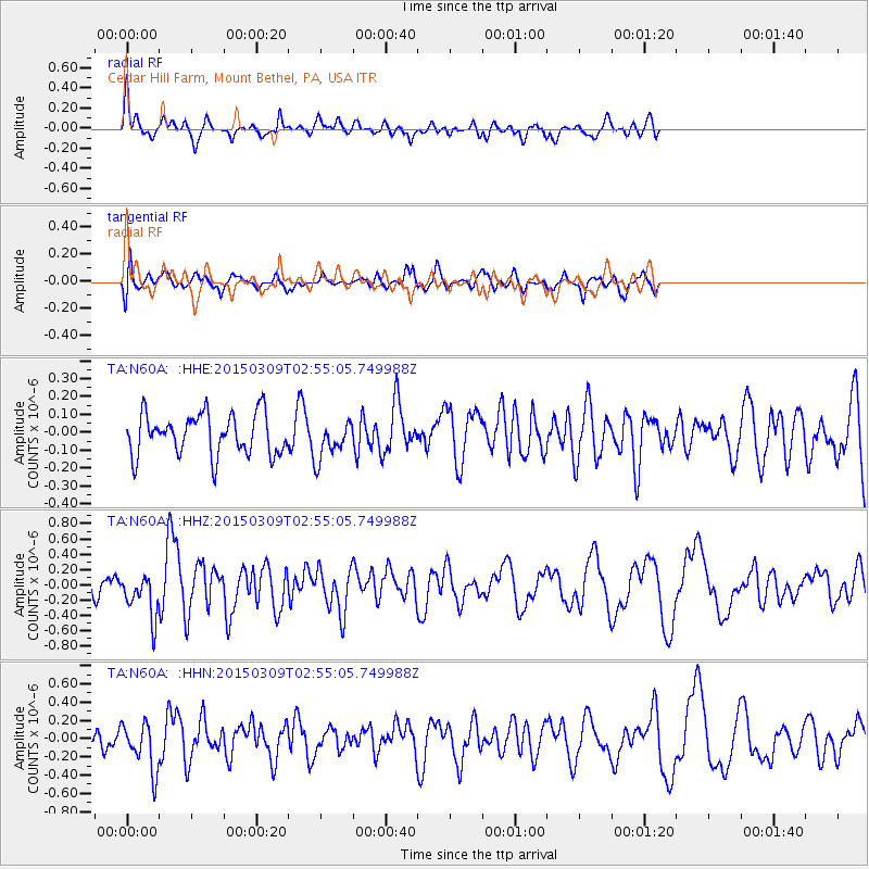
Signal To Noise
| Channel | StoN | STA | LTA |
| TA:N60A: :HHZ:20150309T02:55:05.749988Z | 1.8130689 | 2.859407E-7 | 1.5771089E-7 |
| TA:N60A: :HHN:20150309T02:55:05.749988Z | 2.1794355 | 2.665147E-7 | 1.2228611E-7 |
| TA:N60A: :HHE:20150309T02:55:05.749988Z | 0.91550165 | 1.0507309E-7 | 1.14771055E-7 |
| Arrivals |
| Ps | |
| PpPs | |
| PsPs/PpSs | |


