You are here: Home > Network List > TA - USArray Transportable Network (new EarthScope stations) Stations List
> Station O48A Farmland, IN, USA > Earthquake Result Viewer
O48A Farmland, IN, USA - Earthquake Result Viewer

| Earthquake location: |
South Of Panama |
| Earthquake latitude/longitude: |
6.5/-82.7 |
| Earthquake time(UTC): |
2015/03/09 (068) 02:48:45 GMT |
| Earthquake Depth: |
10 km |
| Earthquake Magnitude: |
5.6 MO |
| Earthquake Catalog/Contributor: |
NEIC PDE/NEIC ALERT |
|
| Network: |
TA USArray Transportable Network (new EarthScope stations) |
| Station: |
O48A Farmland, IN, USA |
| Lat/Lon: |
40.26 N/85.16 W |
| Elevation: |
300 m |
|
| Distance: |
33.7 deg |
| Az: |
356.553 deg |
| Baz: |
175.522 deg |
| Ray Param: |
0.078101076 |
| Estimated Moho Depth: |
57.0 km |
| Estimated Crust Vp/Vs: |
1.71 |
| Assumed Crust Vp: |
6.498 km/s |
| Estimated Crust Vs: |
3.805 km/s |
| Estimated Crust Poisson's Ratio: |
0.24 |
|
| Radial Match: |
80.24126 % |
| Radial Bump: |
400 |
| Transverse Match: |
65.58885 % |
| Transverse Bump: |
400 |
| SOD ConfigId: |
7019011 |
| Insert Time: |
2019-04-17 06:29:50.307 +0000 |
| GWidth: |
2.5 |
| Max Bumps: |
400 |
| Tol: |
0.001 |
|
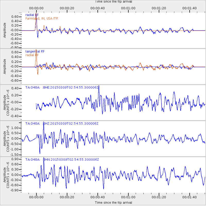
Signal To Noise
| Channel | StoN | STA | LTA |
| TA:O48A: :BHZ:20150309T02:54:55.300006Z | 4.6445265 | 6.1183056E-7 | 1.3173153E-7 |
| TA:O48A: :BHN:20150309T02:54:55.300006Z | 3.887628 | 3.5129509E-7 | 9.036231E-8 |
| TA:O48A: :BHE:20150309T02:54:55.300006Z | 1.1885556 | 1.01053274E-7 | 8.502192E-8 |
| Arrivals |
| Ps | 6.7 SECOND |
| PpPs | 22 SECOND |
| PsPs/PpSs | 29 SECOND |


