You are here: Home > Network List > II - Global Seismograph Network (GSN - IRIS/IDA) Stations List
> Station ABKT Alibek, Turkmenistan > Earthquake Result Viewer
ABKT Alibek, Turkmenistan - Earthquake Result Viewer

| Earthquake location: |
Irian Jaya, Indonesia |
| Earthquake latitude/longitude: |
-2.7/138.9 |
| Earthquake time(UTC): |
1998/07/29 (210) 18:00:29 GMT |
| Earthquake Depth: |
33 km |
| Earthquake Magnitude: |
5.9 MB, 6.7 MS, 6.6 UNKNOWN, 6.2 ME |
| Earthquake Catalog/Contributor: |
WHDF/NEIC |
|
| Network: |
II Global Seismograph Network (GSN - IRIS/IDA) |
| Station: |
ABKT Alibek, Turkmenistan |
| Lat/Lon: |
37.93 N/58.12 E |
| Elevation: |
678 m |
|
| Distance: |
84.4 deg |
| Az: |
308.343 deg |
| Baz: |
97.788 deg |
| Ray Param: |
0.04548226 |
| Estimated Moho Depth: |
11.0 km |
| Estimated Crust Vp/Vs: |
1.81 |
| Assumed Crust Vp: |
6.53 km/s |
| Estimated Crust Vs: |
3.608 km/s |
| Estimated Crust Poisson's Ratio: |
0.28 |
|
| Radial Match: |
97.61076 % |
| Radial Bump: |
400 |
| Transverse Match: |
92.50959 % |
| Transverse Bump: |
400 |
| SOD ConfigId: |
4480 |
| Insert Time: |
2010-03-01 22:54:38.849 +0000 |
| GWidth: |
2.5 |
| Max Bumps: |
400 |
| Tol: |
0.001 |
|
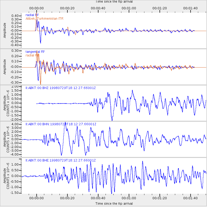
Signal To Noise
| Channel | StoN | STA | LTA |
| II:ABKT:00:BHN:19980729T18:12:27.66001Z | 7.7286134 | 3.2226407E-7 | 4.169753E-8 |
| II:ABKT:00:BHE:19980729T18:12:27.66001Z | 0.87961775 | 3.1042866E-8 | 3.5291315E-8 |
| II:ABKT:00:BHZ:19980729T18:12:27.66001Z | 1.9146245 | 3.6843637E-8 | 1.9243272E-8 |
| Arrivals |
| Ps | 1.4 SECOND |
| PpPs | 4.6 SECOND |
| PsPs/PpSs | 6.0 SECOND |


