You are here: Home > Network List > N4 - Central and EAstern US Network Stations List
> Station D41A Chassel, MI, USA > Earthquake Result Viewer
D41A Chassel, MI, USA - Earthquake Result Viewer
| Earthquake location: |
Northern Alaska |
| Earthquake latitude/longitude: |
67.9/-162.4 |
| Earthquake time(UTC): |
2014/06/07 (158) 04:43:34 GMT |
| Earthquake Depth: |
14 km |
| Earthquake Magnitude: |
6.0 MI |
| Earthquake Catalog/Contributor: |
NEIC PDE/NEIC ALERT |
|
| Network: |
N4 Central and EAstern US Network |
| Station: |
D41A Chassel, MI, USA |
| Lat/Lon: |
47.06 N/88.57 W |
| Elevation: |
271 m |
|
| Distance: |
41.6 deg |
| Az: |
81.346 deg |
| Baz: |
326.799 deg |
| Ray Param: |
0.07367029 |
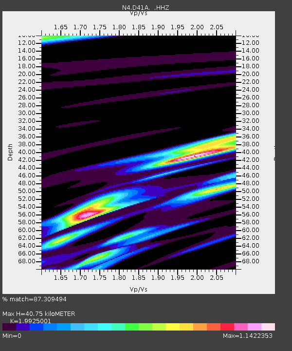
| Estimated Moho Depth: |
40.75 km |
| Estimated Crust Vp/Vs: |
1.99 |
| Assumed Crust Vp: |
6.467 km/s |
| Estimated Crust Vs: |
3.246 km/s |
| Estimated Crust Poisson's Ratio: |
0.33 |
|
| Radial Match: |
87.309494 % |
| Radial Bump: |
344 |
| Transverse Match: |
50.38747 % |
| Transverse Bump: |
331 |
| SOD ConfigId: |
626651 |
| Insert Time: |
2014-06-21 05:15:55.508 +0000 |
| GWidth: |
2.5 |
| Max Bumps: |
400 |
| Tol: |
0.001 |
|

Signal To Noise
| Channel | StoN | STA | LTA |
| N4:D41A: :HHZ:20140607T04:50:50.670013Z | 11.836916 | 1.2602569E-6 | 1.06468356E-7 |
| N4:D41A: :HHN:20140607T04:50:50.670013Z | 6.364833 | 8.353507E-7 | 1.3124472E-7 |
| N4:D41A: :HHE:20140607T04:50:50.670013Z | 5.287018 | 5.6670495E-7 | 1.0718802E-7 |
| Arrivals |
| Ps | 6.7 SECOND |
| PpPs | 18 SECOND |
| PsPs/PpSs | 24 SECOND |


