You are here: Home > Network List > AV - Alaska Volcano Observatory Stations List
> Station MAPS Pakushin Southeast, Makushin Volcano, Alaska > Earthquake Result Viewer
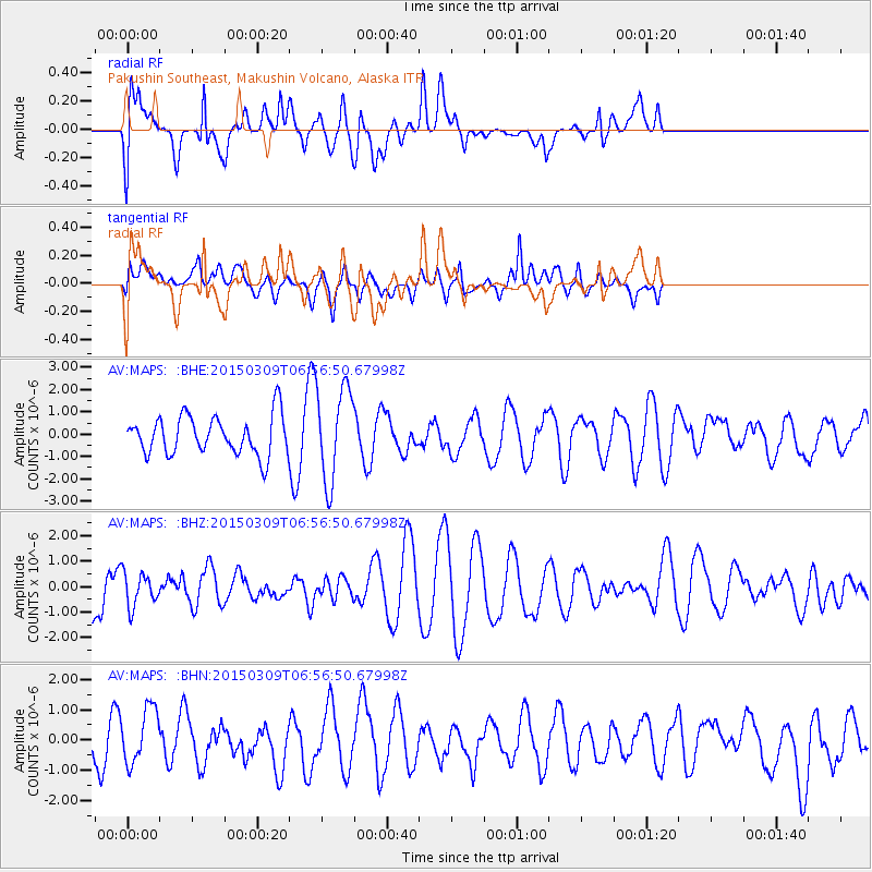
MAPS Pakushin Southeast, Makushin Volcano, Alaska - Earthquake Result Viewer
*The percent match for this event was below the threshold and hence no stack was calculated.
| Earthquake location: |
Banda Sea |
| Earthquake latitude/longitude: |
-7.4/128.8 |
| Earthquake time(UTC): |
2015/03/09 (068) 06:45:20 GMT |
| Earthquake Depth: |
131 km |
| Earthquake Magnitude: |
5.3 MW |
| Earthquake Catalog/Contributor: |
ISC/ISC |
|
| Network: |
AV Alaska Volcano Observatory |
| Station: |
MAPS Pakushin Southeast, Makushin Volcano, Alaska |
| Lat/Lon: |
53.81 N/166.94 W |
| Elevation: |
333 m |
|
| Distance: |
81.2 deg |
| Az: |
32.727 deg |
| Baz: |
244.707 deg |
| Ray Param: |
$rayparam |
*The percent match for this event was below the threshold and hence was not used in the summary stack. |
|
| Radial Match: |
50.119373 % |
| Radial Bump: |
400 |
| Transverse Match: |
39.009754 % |
| Transverse Bump: |
400 |
| SOD ConfigId: |
7019011 |
| Insert Time: |
2019-04-17 06:34:28.069 +0000 |
| GWidth: |
2.5 |
| Max Bumps: |
400 |
| Tol: |
0.001 |
|
Signal To Noise
| Channel | StoN | STA | LTA |
| AV:MAPS: :BHZ:20150309T06:56:50.67998Z | 0.74126494 | 6.624663E-7 | 8.93697E-7 |
| AV:MAPS: :BHN:20150309T06:56:50.67998Z | 1.2837609 | 9.122248E-7 | 7.1058776E-7 |
| AV:MAPS: :BHE:20150309T06:56:50.67998Z | 2.4446208 | 2.1223516E-6 | 8.681721E-7 |
| Arrivals |
| Ps | |
| PpPs | |
| PsPs/PpSs | |


