You are here: Home > Network List > N4 - Central and EAstern US Network Stations List
> Station Y52A Lilburn, GA, USA > Earthquake Result Viewer
Y52A Lilburn, GA, USA - Earthquake Result Viewer
| Earthquake location: |
Northern Alaska |
| Earthquake latitude/longitude: |
67.9/-162.4 |
| Earthquake time(UTC): |
2014/06/07 (158) 04:43:34 GMT |
| Earthquake Depth: |
14 km |
| Earthquake Magnitude: |
6.0 MI |
| Earthquake Catalog/Contributor: |
NEIC PDE/NEIC ALERT |
|
| Network: |
N4 Central and EAstern US Network |
| Station: |
Y52A Lilburn, GA, USA |
| Lat/Lon: |
33.86 N/84.06 W |
| Elevation: |
286 m |
|
| Distance: |
54.7 deg |
| Az: |
86.206 deg |
| Baz: |
332.993 deg |
| Ray Param: |
0.06524252 |
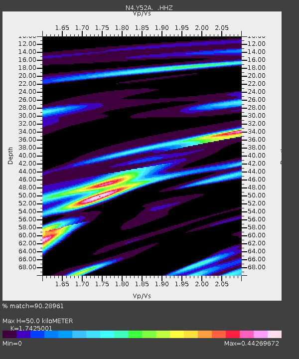
| Estimated Moho Depth: |
50.0 km |
| Estimated Crust Vp/Vs: |
1.74 |
| Assumed Crust Vp: |
6.719 km/s |
| Estimated Crust Vs: |
3.856 km/s |
| Estimated Crust Poisson's Ratio: |
0.25 |
|
| Radial Match: |
90.28961 % |
| Radial Bump: |
305 |
| Transverse Match: |
64.885254 % |
| Transverse Bump: |
400 |
| SOD ConfigId: |
626651 |
| Insert Time: |
2014-06-21 05:20:24.023 +0000 |
| GWidth: |
2.5 |
| Max Bumps: |
400 |
| Tol: |
0.001 |
|

Signal To Noise
| Channel | StoN | STA | LTA |
| N4:Y52A: :HHZ:20140607T04:52:31.950012Z | 16.792898 | 1.4087435E-6 | 8.388924E-8 |
| N4:Y52A: :HHN:20140607T04:52:31.950012Z | 10.944494 | 6.954673E-7 | 6.3544945E-8 |
| N4:Y52A: :HHE:20140607T04:52:31.950012Z | 5.1460958 | 3.505268E-7 | 6.811509E-8 |
| Arrivals |
| Ps | 5.9 SECOND |
| PpPs | 19 SECOND |
| PsPs/PpSs | 25 SECOND |


