You are here: Home > Network List > TA - USArray Transportable Network (new EarthScope stations) Stations List
> Station A21K Barrow, AK, USA > Earthquake Result Viewer
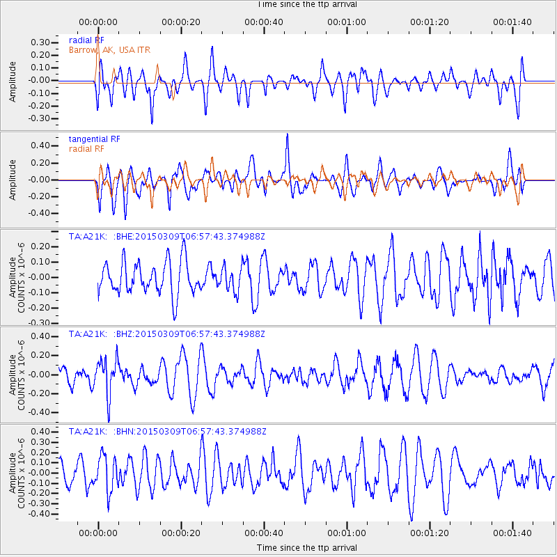
A21K Barrow, AK, USA - Earthquake Result Viewer
*The percent match for this event was below the threshold and hence no stack was calculated.
| Earthquake location: |
Banda Sea |
| Earthquake latitude/longitude: |
-7.4/128.8 |
| Earthquake time(UTC): |
2015/03/09 (068) 06:45:20 GMT |
| Earthquake Depth: |
131 km |
| Earthquake Magnitude: |
5.3 MW |
| Earthquake Catalog/Contributor: |
ISC/ISC |
|
| Network: |
TA USArray Transportable Network (new EarthScope stations) |
| Station: |
A21K Barrow, AK, USA |
| Lat/Lon: |
71.32 N/156.62 W |
| Elevation: |
577 m |
|
| Distance: |
92.1 deg |
| Az: |
18.108 deg |
| Baz: |
253.104 deg |
| Ray Param: |
$rayparam |
*The percent match for this event was below the threshold and hence was not used in the summary stack. |
|
| Radial Match: |
52.558685 % |
| Radial Bump: |
400 |
| Transverse Match: |
65.30344 % |
| Transverse Bump: |
400 |
| SOD ConfigId: |
7019011 |
| Insert Time: |
2019-04-17 06:35:47.578 +0000 |
| GWidth: |
2.5 |
| Max Bumps: |
400 |
| Tol: |
0.001 |
|
Signal To Noise
| Channel | StoN | STA | LTA |
| TA:A21K: :BHZ:20150309T06:57:43.374988Z | 2.266944 | 1.9182222E-7 | 8.46171E-8 |
| TA:A21K: :BHN:20150309T06:57:43.374988Z | 1.8279309 | 1.7536887E-7 | 9.5938454E-8 |
| TA:A21K: :BHE:20150309T06:57:43.374988Z | 0.74937093 | 7.8412754E-8 | 1.04638104E-7 |
| Arrivals |
| Ps | |
| PpPs | |
| PsPs/PpSs | |


