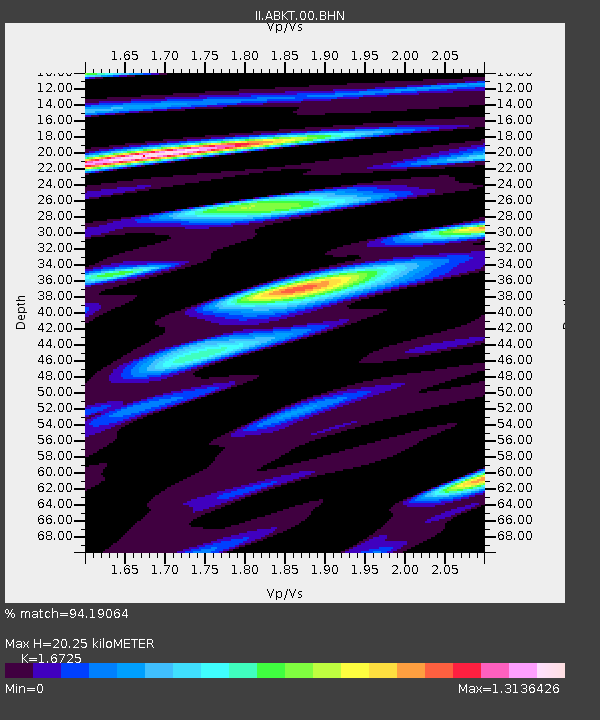
ABKT Alibek, Turkmenistan - Earthquake Result Viewer

Earthquake location: Nicobar Islands, India Region
Earthquake latitude/longitude: 6.9/92.5
Earthquake time(UTC): 2006/06/21 (172) 12:34:52 GMT
Earthquake Depth: 16 km
Earthquake Magnitude: 5.7 MB, 5.7 MS, 5.9 MW, 5.9 MW
Earthquake Catalog/Contributor: WHDF/NEIC
Network: II Global Seismograph Network (GSN - IRIS/IDA)
Station: ABKT Alibek, Turkmenistan
Lat/Lon: 37.93 N/58.12 E
Elevation: 678 m
Distance: 43.8 deg
Az: 319.884 deg
Baz: 126.007 deg
Ray Param: 0.07229747
Estimated Moho Depth: 20.25 km
Estimated Crust Vp/Vs: 1.67
Assumed Crust Vp: 6.53 km/s
Estimated Crust Vs: 3.905 km/s
Estimated Crust Poisson's Ratio: 0.22
Radial Match: 94.19064 %
Radial Bump: 400
Transverse Match: 89.55973 %
Transverse Bump: 400
SOD ConfigId: 5423
Insert Time: 2010-03-01 22:55:57.781 +0000
GWidth: 2.5
Max Bumps: 400
Tol: 0.001

Signal To Noise

ChannelStoNSTALTA
II:ABKT:00:BHN:20060621T12:42:26.802009Z6.2513842.0719696E-73.3144175E-8
II:ABKT:00:BHE:20060621T12:42:26.802009Z6.16810232.0598355E-73.3394965E-8
II:ABKT:00:BHZ:20060621T12:42:26.802009Z11.3936815.5754964E-74.893499E-8
Arrivals
Ps2.2 SECOND
PpPs7.7 SECOND
PsPs/PpSs10.0 SECOND