You are here: Home > Network List > TA - USArray Transportable Network (new EarthScope stations) Stations List
> Station G45A Suttons Bay, MI, USA > Earthquake Result Viewer
G45A Suttons Bay, MI, USA - Earthquake Result Viewer

| Earthquake location: |
Northern Alaska |
| Earthquake latitude/longitude: |
67.9/-162.4 |
| Earthquake time(UTC): |
2014/06/07 (158) 04:43:34 GMT |
| Earthquake Depth: |
14 km |
| Earthquake Magnitude: |
6.0 MI |
| Earthquake Catalog/Contributor: |
NEIC PDE/NEIC ALERT |
|
| Network: |
TA USArray Transportable Network (new EarthScope stations) |
| Station: |
G45A Suttons Bay, MI, USA |
| Lat/Lon: |
45.04 N/85.66 W |
| Elevation: |
284 m |
|
| Distance: |
44.4 deg |
| Az: |
80.432 deg |
| Baz: |
328.218 deg |
| Ray Param: |
0.07192574 |
| Estimated Moho Depth: |
16.25 km |
| Estimated Crust Vp/Vs: |
1.97 |
| Assumed Crust Vp: |
6.483 km/s |
| Estimated Crust Vs: |
3.286 km/s |
| Estimated Crust Poisson's Ratio: |
0.33 |
|
| Radial Match: |
81.0195 % |
| Radial Bump: |
400 |
| Transverse Match: |
53.250805 % |
| Transverse Bump: |
400 |
| SOD ConfigId: |
626651 |
| Insert Time: |
2014-06-21 05:32:33.369 +0000 |
| GWidth: |
2.5 |
| Max Bumps: |
400 |
| Tol: |
0.001 |
|
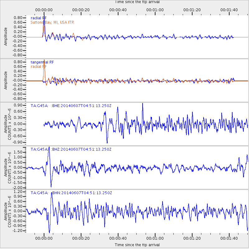
Signal To Noise
| Channel | StoN | STA | LTA |
| TA:G45A: :BHZ:20140607T04:51:13.250Z | 14.562467 | 9.899483E-7 | 6.7979435E-8 |
| TA:G45A: :BHN:20140607T04:51:13.250Z | 4.2958665 | 6.209477E-7 | 1.4454538E-7 |
| TA:G45A: :BHE:20140607T04:51:13.250Z | 3.3300662 | 3.832147E-7 | 1.150772E-7 |
| Arrivals |
| Ps | 2.6 SECOND |
| PpPs | 7.0 SECOND |
| PsPs/PpSs | 9.6 SECOND |


