You are here: Home > Network List > TA - USArray Transportable Network (new EarthScope stations) Stations List
> Station H47A Mio, MI, USA > Earthquake Result Viewer
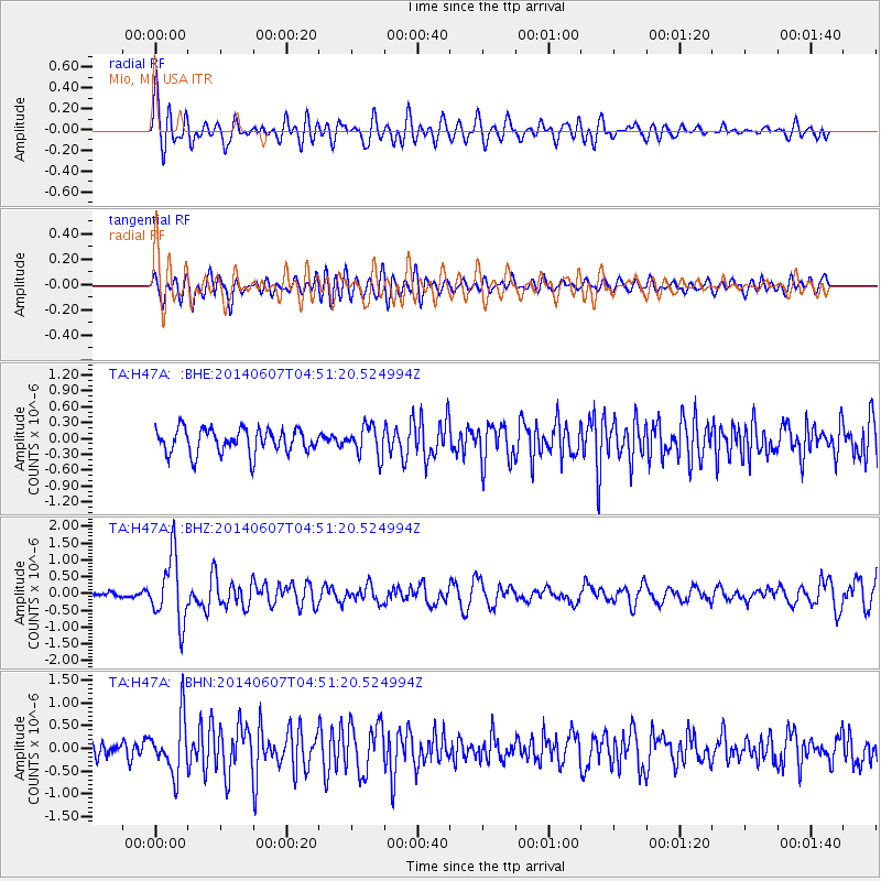
H47A Mio, MI, USA - Earthquake Result Viewer
*The percent match for this event was below the threshold and hence no stack was calculated.
| Earthquake location: |
Northern Alaska |
| Earthquake latitude/longitude: |
67.9/-162.4 |
| Earthquake time(UTC): |
2014/06/07 (158) 04:43:34 GMT |
| Earthquake Depth: |
14 km |
| Earthquake Magnitude: |
6.0 MI |
| Earthquake Catalog/Contributor: |
NEIC PDE/NEIC ALERT |
|
| Network: |
TA USArray Transportable Network (new EarthScope stations) |
| Station: |
H47A Mio, MI, USA |
| Lat/Lon: |
44.60 N/84.21 W |
| Elevation: |
356 m |
|
| Distance: |
45.3 deg |
| Az: |
79.512 deg |
| Baz: |
328.586 deg |
| Ray Param: |
$rayparam |
*The percent match for this event was below the threshold and hence was not used in the summary stack. |
|
| Radial Match: |
67.14503 % |
| Radial Bump: |
400 |
| Transverse Match: |
57.62287 % |
| Transverse Bump: |
400 |
| SOD ConfigId: |
626651 |
| Insert Time: |
2014-06-21 05:33:43.412 +0000 |
| GWidth: |
2.5 |
| Max Bumps: |
400 |
| Tol: |
0.001 |
|
Signal To Noise
| Channel | StoN | STA | LTA |
| TA:H47A: :BHZ:20140607T04:51:20.524994Z | 7.0999556 | 9.778123E-7 | 1.377209E-7 |
| TA:H47A: :BHN:20140607T04:51:20.524994Z | 2.9928718 | 6.000865E-7 | 2.0050524E-7 |
| TA:H47A: :BHE:20140607T04:51:20.524994Z | 1.2091056 | 2.8032514E-7 | 2.3184505E-7 |
| Arrivals |
| Ps | |
| PpPs | |
| PsPs/PpSs | |


