You are here: Home > Network List > TA - USArray Transportable Network (new EarthScope stations) Stations List
> Station M47A Cromwell, IN, USA > Earthquake Result Viewer
M47A Cromwell, IN, USA - Earthquake Result Viewer
| Earthquake location: |
Northern Alaska |
| Earthquake latitude/longitude: |
67.9/-162.4 |
| Earthquake time(UTC): |
2014/06/07 (158) 04:43:34 GMT |
| Earthquake Depth: |
14 km |
| Earthquake Magnitude: |
6.0 MI |
| Earthquake Catalog/Contributor: |
NEIC PDE/NEIC ALERT |
|
| Network: |
TA USArray Transportable Network (new EarthScope stations) |
| Station: |
M47A Cromwell, IN, USA |
| Lat/Lon: |
41.36 N/85.62 W |
| Elevation: |
283 m |
|
| Distance: |
47.6 deg |
| Az: |
83.025 deg |
| Baz: |
330.045 deg |
| Ray Param: |
0.06988819 |
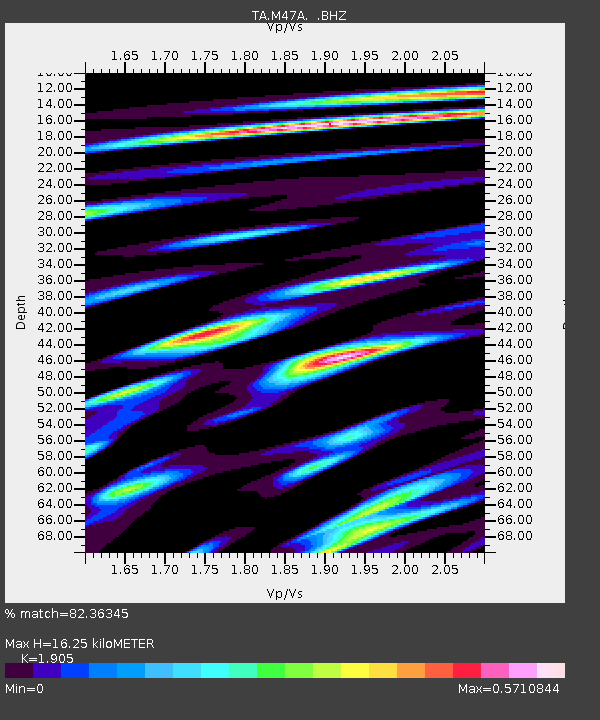
| Estimated Moho Depth: |
16.25 km |
| Estimated Crust Vp/Vs: |
1.90 |
| Assumed Crust Vp: |
6.498 km/s |
| Estimated Crust Vs: |
3.411 km/s |
| Estimated Crust Poisson's Ratio: |
0.31 |
|
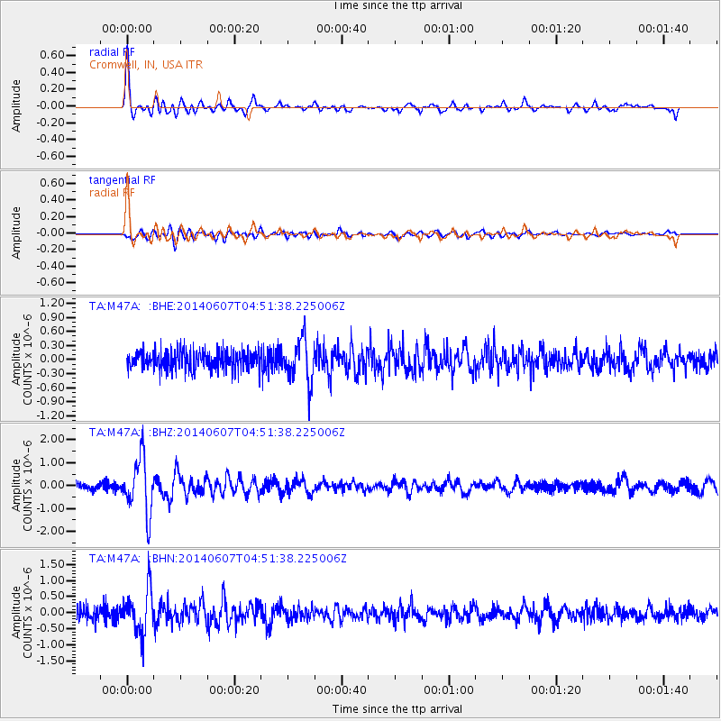
| Radial Match: |
82.36345 % |
| Radial Bump: |
339 |
| Transverse Match: |
72.14265 % |
| Transverse Bump: |
400 |
| SOD ConfigId: |
626651 |
| Insert Time: |
2014-06-21 05:40:11.956 +0000 |
| GWidth: |
2.5 |
| Max Bumps: |
400 |
| Tol: |
0.001 |
|
Signal To Noise
| Channel | StoN | STA | LTA |
| TA:M47A: :BHZ:20140607T04:51:38.225006Z | 7.8346257 | 1.2084344E-6 | 1.5424277E-7 |
| TA:M47A: :BHN:20140607T04:51:38.225006Z | 3.2263305 | 6.926486E-7 | 2.1468618E-7 |
| TA:M47A: :BHE:20140607T04:51:38.225006Z | 2.2630026 | 4.5540665E-7 | 2.0124E-7 |
| Arrivals |
| Ps | 2.4 SECOND |
| PpPs | 6.9 SECOND |
| PsPs/PpSs | 9.3 SECOND |


