You are here: Home > Network List > II - Global Seismograph Network (GSN - IRIS/IDA) Stations List
> Station ABKT Alibek, Turkmenistan > Earthquake Result Viewer
ABKT Alibek, Turkmenistan - Earthquake Result Viewer

| Earthquake location: |
Taiwan Region |
| Earthquake latitude/longitude: |
22.8/121.4 |
| Earthquake time(UTC): |
2006/04/15 (105) 22:40:54 GMT |
| Earthquake Depth: |
18 km |
| Earthquake Magnitude: |
5.5 MB, 5.7 MS, 5.9 MW, 5.9 MW |
| Earthquake Catalog/Contributor: |
WHDF/NEIC |
|
| Network: |
II Global Seismograph Network (GSN - IRIS/IDA) |
| Station: |
ABKT Alibek, Turkmenistan |
| Lat/Lon: |
37.93 N/58.12 E |
| Elevation: |
678 m |
|
| Distance: |
55.6 deg |
| Az: |
301.204 deg |
| Baz: |
86.499 deg |
| Ray Param: |
0.06464351 |
| Estimated Moho Depth: |
13.0 km |
| Estimated Crust Vp/Vs: |
1.65 |
| Assumed Crust Vp: |
6.53 km/s |
| Estimated Crust Vs: |
3.952 km/s |
| Estimated Crust Poisson's Ratio: |
0.21 |
|
| Radial Match: |
97.14949 % |
| Radial Bump: |
400 |
| Transverse Match: |
95.80064 % |
| Transverse Bump: |
400 |
| SOD ConfigId: |
5423 |
| Insert Time: |
2010-03-01 22:56:18.973 +0000 |
| GWidth: |
2.5 |
| Max Bumps: |
400 |
| Tol: |
0.001 |
|
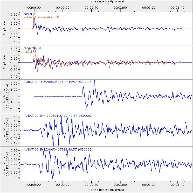
Signal To Noise
| Channel | StoN | STA | LTA |
| II:ABKT:00:BHN:20060415T22:49:57.962009Z | 2.0225568 | 3.4776722E-8 | 1.7194436E-8 |
| II:ABKT:00:BHE:20060415T22:49:57.962009Z | 7.7870007 | 2.1018128E-7 | 2.6991303E-8 |
| II:ABKT:00:BHZ:20060415T22:49:57.962009Z | 21.994436 | 5.8299247E-7 | 2.6506363E-8 |
| Arrivals |
| Ps | 1.4 SECOND |
| PpPs | 5.0 SECOND |
| PsPs/PpSs | 6.4 SECOND |


