You are here: Home > Network List > TA - USArray Transportable Network (new EarthScope stations) Stations List
> Station P57A Homestead Farm, Martinsburg, WV, USA > Earthquake Result Viewer
P57A Homestead Farm, Martinsburg, WV, USA - Earthquake Result Viewer
| Earthquake location: |
Northern Alaska |
| Earthquake latitude/longitude: |
67.9/-162.4 |
| Earthquake time(UTC): |
2014/06/07 (158) 04:43:34 GMT |
| Earthquake Depth: |
14 km |
| Earthquake Magnitude: |
6.0 MI |
| Earthquake Catalog/Contributor: |
NEIC PDE/NEIC ALERT |
|
| Network: |
TA USArray Transportable Network (new EarthScope stations) |
| Station: |
P57A Homestead Farm, Martinsburg, WV, USA |
| Lat/Lon: |
39.48 N/78.01 W |
| Elevation: |
191 m |
|
| Distance: |
52.1 deg |
| Az: |
77.59 deg |
| Baz: |
331.453 deg |
| Ray Param: |
0.06699784 |
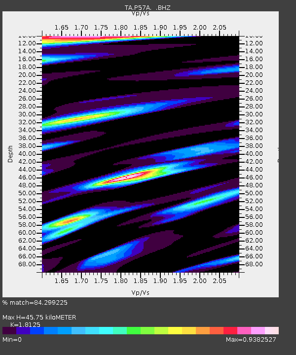
| Estimated Moho Depth: |
45.75 km |
| Estimated Crust Vp/Vs: |
1.81 |
| Assumed Crust Vp: |
6.159 km/s |
| Estimated Crust Vs: |
3.398 km/s |
| Estimated Crust Poisson's Ratio: |
0.28 |
|
| Radial Match: |
84.299225 % |
| Radial Bump: |
395 |
| Transverse Match: |
54.97287 % |
| Transverse Bump: |
400 |
| SOD ConfigId: |
626651 |
| Insert Time: |
2014-06-21 05:43:50.009 +0000 |
| GWidth: |
2.5 |
| Max Bumps: |
400 |
| Tol: |
0.001 |
|

Signal To Noise
| Channel | StoN | STA | LTA |
| TA:P57A: :BHZ:20140607T04:52:12.200012Z | 11.011857 | 8.982318E-7 | 8.156951E-8 |
| TA:P57A: :BHN:20140607T04:52:12.200012Z | 5.823569 | 3.8580646E-7 | 6.624914E-8 |
| TA:P57A: :BHE:20140607T04:52:12.200012Z | 2.9140987 | 2.507112E-7 | 8.603388E-8 |
| Arrivals |
| Ps | 6.3 SECOND |
| PpPs | 20 SECOND |
| PsPs/PpSs | 26 SECOND |


