You are here: Home > Network List > TA - USArray Transportable Network (new EarthScope stations) Stations List
> Station Q53A Leroy, WV, USA > Earthquake Result Viewer
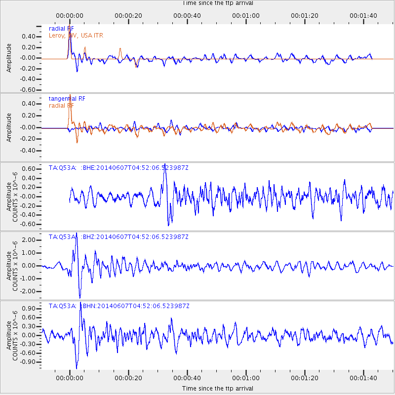
Q53A Leroy, WV, USA - Earthquake Result Viewer
*The percent match for this event was below the threshold and hence no stack was calculated.
| Earthquake location: |
Northern Alaska |
| Earthquake latitude/longitude: |
67.9/-162.4 |
| Earthquake time(UTC): |
2014/06/07 (158) 04:43:34 GMT |
| Earthquake Depth: |
14 km |
| Earthquake Magnitude: |
6.0 MI |
| Earthquake Catalog/Contributor: |
NEIC PDE/NEIC ALERT |
|
| Network: |
TA USArray Transportable Network (new EarthScope stations) |
| Station: |
Q53A Leroy, WV, USA |
| Lat/Lon: |
38.86 N/81.53 W |
| Elevation: |
310 m |
|
| Distance: |
51.3 deg |
| Az: |
81.026 deg |
| Baz: |
331.374 deg |
| Ray Param: |
$rayparam |
*The percent match for this event was below the threshold and hence was not used in the summary stack. |
|
| Radial Match: |
79.74025 % |
| Radial Bump: |
400 |
| Transverse Match: |
73.684555 % |
| Transverse Bump: |
400 |
| SOD ConfigId: |
626651 |
| Insert Time: |
2014-06-21 05:44:17.766 +0000 |
| GWidth: |
2.5 |
| Max Bumps: |
400 |
| Tol: |
0.001 |
|
Signal To Noise
| Channel | StoN | STA | LTA |
| TA:Q53A: :BHZ:20140607T04:52:06.523987Z | 11.875365 | 1.2336352E-6 | 1.0388187E-7 |
| TA:Q53A: :BHN:20140607T04:52:06.523987Z | 4.8214087 | 5.380555E-7 | 1.11597146E-7 |
| TA:Q53A: :BHE:20140607T04:52:06.523987Z | 3.6962066 | 3.623331E-7 | 9.802837E-8 |
| Arrivals |
| Ps | |
| PpPs | |
| PsPs/PpSs | |


